
Size of this preview: 667 × 599 pixels. Other resolutions: 267 × 240 pixels | 534 × 480 pixels | 855 × 768 pixels | 1,139 × 1,024 pixels | 1,905 × 1,712 pixels.
Original file (1,905 × 1,712 pixels, file size: 358 KB, MIME type: image/jpeg)
| This is a file from the Wikimedia Commons. Information from its description page there is shown below. Commons is a freely licensed media file repository. You can help. |
Summary
| Description |
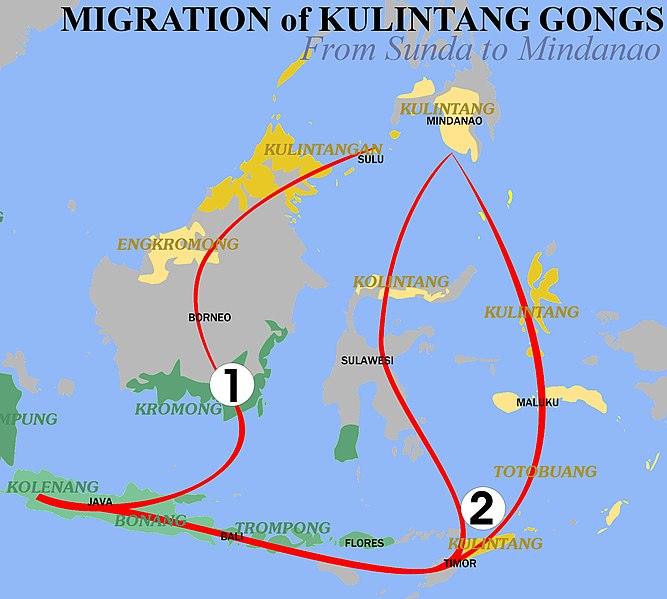
English: This map shows one of the two migration routes that the kulintang gong is believed to have made as it went through insular Southeast Asia. |
| Date | |
| Source |
|
| Author | Philip Dominguez Mercurio (PhilipDM) |
References
- ↑ a b Cadar, Usopay Hamdag (1971). The Maranao Kolintang Music: An Analysis of the Instruments, Musical Organization, Ethmologies, and Historical Documents. Seattle, WA: University of Washington.
- ↑ Frame, Edward M.. "The Musical Instruments of Sabah, Malaysia." Ethnomusicology 26(1982):
- ↑ a b "Embassy of the Republic of Indonesia." Ethnic Music. 2005. Embassy of the Republic of Indonesia in Berlin - Germany. 29 Jan 2007
External links
- Traditional Music of the Southern Philippines - An online textbook about Kulintang Music with a extensive section concerning its history in insular Southeast Asia.(english)
Licensing
I, the copyright holder of this work, hereby publish it under the following license:
This file is licensed under the Creative Commons Attribution-Share Alike 2.5 Generic license.
- You are free:
- to share – to copy, distribute and transmit the work
- to remix – to adapt the work
- Under the following conditions:
- attribution – You must give appropriate credit, provide a link to the license, and indicate if changes were made. You may do so in any reasonable manner, but not in any way that suggests the licensor endorses you or your use.
- share alike – If you remix, transform, or build upon the material, you must distribute your contributions under the same or compatible license as the original.
File history
Click on a date/time to view the file as it appeared at that time.
| Date/Time | Thumbnail | Dimensions | User | Comment | |
|---|---|---|---|---|---|
| current | 22:37, 28 February 2007 | | 1,905 × 1,712 (358 KB) | PhilipDM | '''en:''' *Description: This map shows one of the two migration routes that the kulintang gong is believed to have made as it went through insular Southeast Asia. *Author: Philip Dominguez Mercurio (PhilipDM) |
File usage
The following pages on the English Wikipedia use this file (pages on other projects are not listed):
Global file usage
The following other wikis use this file:
- Usage on de.wikipedia.org