.svg)
.svg&action=edit&redlink=1)

Size of this PNG preview of this SVG file: 386 × 599 pixels. Other resolutions: 155 × 240 pixels | 309 × 480 pixels | 495 × 768 pixels | 660 × 1,024 pixels | 1,320 × 2,048 pixels | 2,691 × 4,175 pixels.
Original file (SVG file, nominally 2,691 × 4,175 pixels, file size: 124 KB)
| This is a file from the Wikimedia Commons. Information from its description page there is shown below. Commons is a freely licensed media file repository. You can help. |
.svg)
Summary
| Description | |
| Date | |
| Source | Own work |
| Author | Vonvikken |
| SVG development |
Licensing
| This work has been released into the public domain by its author, Vonvikken. This applies worldwide. In some countries this may not be legally possible; if so: |
File history
Click on a date/time to view the file as it appeared at that time.
| Date/Time | Thumbnail | Dimensions | User | Comment | |
|---|---|---|---|---|---|
| current | 14:37, 22 February 2019 | | 2,691 × 4,175 (124 KB) | Afnecors | Nuovi comuni: Barbarano Mossano, Colceresa, Lusiana Conco e Valbrenta |
| 20:59, 8 April 2017 |  | 2,691 × 4,175 (173 KB) | Krepideia | New municipality: Val Liona. Valid svg | |
| 20:58, 8 April 2017 |  | 2,691 × 4,175 (173 KB) | Krepideia | da271d | |
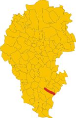
| 10:54, 17 May 2011 |  | 2,691 × 4,175 (169 KB) | File Upload Bot (Vonvikken) | == {{int:filedesc}} == {{Information |Description={{DescrMapComuneItaly|Nanto|Nanto (Italy)||VI}} |Source={{own}} |Author=Vonvikken |Date=2011-05-17 |Permission= }} {{Valid SVG}} == {{int:license}} == {{PD-user|Vonvikken}} |
File usage
The following pages on the English Wikipedia use this file (pages on other projects are not listed):
Global file usage
The following other wikis use this file:
- Usage on ar.wikipedia.org
- Usage on azb.wikipedia.org
- Usage on bg.wikipedia.org
- Usage on ceb.wikipedia.org
- Usage on el.wikipedia.org
- Usage on es.wikipedia.org
- Usage on eu.wikipedia.org
- Usage on fa.wikipedia.org
- Usage on fr.wikipedia.org
- Usage on hu.wikipedia.org
- Usage on ia.wikipedia.org
- Usage on it.wikipedia.org
- Usage on ja.wikipedia.org
- Usage on la.wikipedia.org
- Usage on lmo.wikipedia.org
- Usage on pl.wikipedia.org
- Usage on ro.wikipedia.org
- Usage on sv.wikipedia.org
- Usage on tt.wikipedia.org
- Usage on www.wikidata.org
- Usage on zh-min-nan.wikipedia.org
.svg)