No higher resolution available.
Map_of_Afsluitdijk.png (247 × 303 pixels, file size: 15 KB, MIME type: image/png)
| This is a file from the Wikimedia Commons. Information from its description page there is shown below. Commons is a freely licensed media file repository. You can help. |
Summary
| Description |
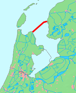
English: Map of Afsluitdijk, Netherlands
日本語: オランダのアフシュライトダイク(締め切り大堤防)の地図 |
| Date | |
| Source | based on Image:MapNetherlandsWater.PNG |
| Author | inoue-hiro |
Licensing
This image is in the public domain because it came from the site https://www.demis.nl/products/web-map-server/examples/ and was released by the copyright holder. Permission is granted to copy, distribute and/or modify this map since it is based on free of copyright images from: www.demis.nl. See also approval email on de.wp and its clarification.
|
| This work has been released into the public domain by its copyright holder, www.demis.nl. This applies worldwide. In some countries this may not be legally possible; if so: www.demis.nl grants anyone the right to use this work for any purpose, without any conditions, unless such conditions are required by law.
|
File history
Click on a date/time to view the file as it appeared at that time.
| Date/Time | Thumbnail | Dimensions | User | Comment | |
|---|---|---|---|---|---|
| current | 13:29, 9 October 2015 | | 247 × 303 (15 KB) | Io Herodotus | markenwaard removed |
| 12:27, 6 February 2009 |  | 247 × 303 (7 KB) | Inoue-hiro | {{Information |Description={{en|1=Map of Afsluitdijk, Netherlands}} {{ja|1=オランダのアフシュライトダイク(締め切り大堤防)の地図}} |Source=based on Image:MapNetherlandsWater.PNG |Author=inoue-hiro |Date=2009/02/06 |Permiss |
File usage
No pages on the English Wikipedia use this file (pages on other projects are not listed).
Global file usage
The following other wikis use this file:
- Usage on de.wikipedia.org
- Usage on en.wikiversity.org
- Usage on eo.wikipedia.org
- Usage on io.wikipedia.org
- Usage on ja.wikipedia.org
- Usage on vls.wikipedia.org
- Usage on zh.wikipedia.org