No higher resolution available.
Map_nw_bougainville_1945.jpg (220 × 533 pixels, file size: 95 KB, MIME type: image/jpeg)
| Description |
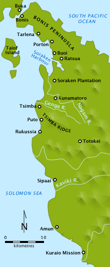
Simple colour map of north west Bouganville island, location of the battles of Tsimba Ridge and Porton Plantation in 1945. | ||
|---|---|---|---|
| Source |
Own work created in Adobe Fireworks
| ||
| Date |
2010-03-29 | ||
| Author |
Chris Rees User:SpoolWhippets | ||
| Permission (Reusing this file) |
|
 | This file is a candidate to be copied to Wikimedia Commons.
Any user may perform this transfer; refer to Wikipedia:Moving files to Commons for details. If this file has problems with attribution, copyright, or is otherwise ineligible for Commons, then remove this tag and DO NOT transfer it; repeat violators may be blocked from editing. Other Instructions
| ||
| |||
File history
Click on a date/time to view the file as it appeared at that time.
| Date/Time | Thumbnail | Dimensions | User | Comment | |
|---|---|---|---|---|---|
| current | 11:20, 30 March 2010 | 220 × 533 (95 KB) | SpoolWhippets (talk | contribs) | {{Information |Description=Simple colour map of north west Bouganville island, location of the battles of Tsimba Ridge and Porton Plantation in 1945. |Source=Own work created in Adobe Fireworks<br/> *Data sources: **Coastlines: File:Un-bougainville.png + |
You cannot overwrite this file.
File usage
The following pages on the English Wikipedia use this file (pages on other projects are not listed):