
Size of this preview: 600 × 600 pixels. Other resolutions: 240 × 240 pixels | 480 × 480 pixels | 768 × 768 pixels | 1,050 × 1,050 pixels.
Original file (1,050 × 1,050 pixels, file size: 728 KB, MIME type: image/jpeg)
| This is a file from the Wikimedia Commons. Information from its description page there is shown below. Commons is a freely licensed media file repository. You can help. |
Summary
| Artist |
Unknown artist |
|||||||||||||||||||||||
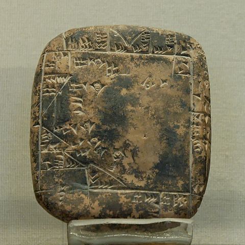
| Description |
English: Map of a property belonging to the city of Umma, indicating the acreage of each parcel. Clay, Ur III.
Français : Plan d'un terrain dépendant de la ville d'Umma, précisant la superficie de chaque parcelle. Argile, Ur III. |
|||||||||||||||||||||||
| Collection |
|
|||||||||||||||||||||||
| Current location |
AO 5677 |
|||||||||||||||||||||||
| Accession number |
Department of Oriental Antiquities, Richelieu, ground floor, room 2 |
|||||||||||||||||||||||
| Credit line | Purchase, 1911 | |||||||||||||||||||||||
| Source/Photographer | Jastrow (2006) | |||||||||||||||||||||||

Licensing
| I, the copyright holder of this work, release this work into the public domain. This applies worldwide. In some countries this may not be legally possible; if so: I grant anyone the right to use this work for any purpose, without any conditions, unless such conditions are required by law. |
File history
Click on a date/time to view the file as it appeared at that time.
| Date/Time | Thumbnail | Dimensions | User | Comment | |
|---|---|---|---|---|---|
| current | 18:05, 11 June 2006 | | 1,050 × 1,050 (728 KB) | Jastrow | {{Louvre-ext |Unknown |Map of a property belonging to the city of Umma, indicating the acreage of each parcel. Clay, Ur III. |Unspecified |Purchase, 1911 |Department of Oriental Antiquities, Richelieu, ground floor, room 2 |AO 5677 |[[:User:Jastrow|Jastr |
File usage
The following pages on the English Wikipedia use this file (pages on other projects are not listed):
Global file usage
The following other wikis use this file:
- Usage on ca.wikipedia.org
- Usage on en.wikibooks.org
- Usage on es.wikipedia.org
- Usage on fr.wikipedia.org
- Usage on it.wikipedia.org
- Usage on ja.wikibooks.org
- Usage on pt.wikipedia.org