Size of this preview: 592 × 599 pixels. Other resolutions: 237 × 240 pixels | 474 × 480 pixels | 759 × 768 pixels | 1,012 × 1,024 pixels | 1,972 × 1,996 pixels.
Original file (1,972 × 1,996 pixels, file size: 329 KB, MIME type: image/png)
| This is a file from the Wikimedia Commons. Information from its description page there is shown below. Commons is a freely licensed media file repository. You can help. |
| Description |
|
| Date | see file history |
| Source | Own work |
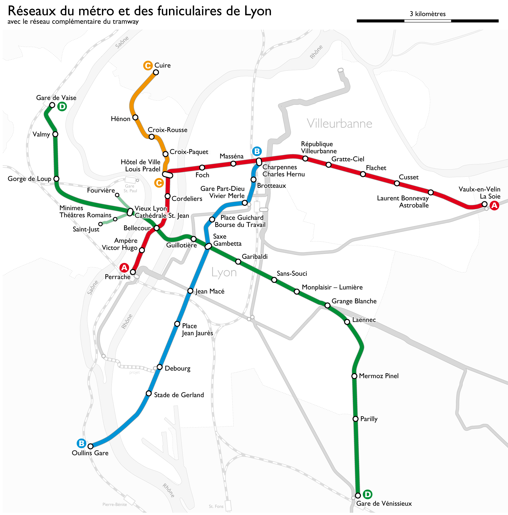
| Author | Maximilian Dörrbecker (Chumwa) |
| Permission (Reusing this file) |
I, the copyright holder of this work, hereby publish it under the following license: This file is licensed under the Creative Commons Attribution-Share Alike 2.5 Generic license.
Sie dürfen das Bild zu den folgenden Bedingungen nutzen:
|
| Other versions |
|


|
This transport map image could be re-created using vector graphics as an SVG file. This has several advantages; see Commons:Media for cleanup for more information. If an SVG form of this image is available, please upload it and afterwards replace this template with
{{vector version available|new image name}}.
It is recommended to name the SVG file “Lyon - Metro network map.svg”—then the template Vector version available (or Vva) does not need the new image name parameter. |
File history
Click on a date/time to view the file as it appeared at that time.
| Date/Time | Thumbnail | Dimensions | User | Comment | |
|---|---|---|---|---|---|
| current | 17:01, 5 September 2021 | | 1,972 × 1,996 (329 KB) | NordNordWest | Saône -> Rhône |
| 21:24, 15 December 2013 |  | 1,972 × 1,996 (474 KB) | Chumwa | update | |
| 07:21, 28 August 2010 |  | 1,972 × 1,996 (530 KB) | Chumwa | {{Information |Description= *{{ de }} Karte von Lyon: Metrolinien mit Straßenbahn- und Trolleyblinien Cristallis im Hintergrund, Stand August 2010 *{{ en }} Map of Lyon: Metro with tramway and trolleybus Cristallis routes in the background as in August 2 |
File usage
The following pages on the English Wikipedia use this file (pages on other projects are not listed):
Global file usage
The following other wikis use this file:
- Usage on be-tarask.wikipedia.org
- Usage on bn.wikipedia.org
- Usage on ca.wikipedia.org
- Usage on cs.wikipedia.org
- Usage on de.wikipedia.org
- Usage on eo.wikipedia.org
- Usage on es.wikipedia.org
- Usage on eu.wikipedia.org
- Usage on fa.wikipedia.org
- Usage on hu.wikipedia.org
- Usage on id.wikipedia.org
- Usage on it.wikipedia.org
- Usage on ja.wikipedia.org
- Usage on jv.wikipedia.org
- Usage on ka.wikipedia.org
- Usage on ko.wikipedia.org
- Usage on mk.wikipedia.org
- Usage on nl.wikipedia.org
- Usage on pl.wikipedia.org
- Usage on pt.wikipedia.org
- Usage on sv.wikipedia.org
- Usage on th.wikipedia.org
- Usage on tr.wikipedia.org
- Usage on uk.wikipedia.org
- Usage on uz.wikipedia.org
- Usage on www.wikidata.org
- Usage on wuu.wikipedia.org