
Size of this preview: 800 × 377 pixels. Other resolutions: 320 × 151 pixels | 640 × 301 pixels | 1,024 × 482 pixels | 1,280 × 603 pixels | 2,509 × 1,181 pixels.
Original file (2,509 × 1,181 pixels, file size: 908 KB, MIME type: image/png)
| This is a file from the Wikimedia Commons. Information from its description page there is shown below. Commons is a freely licensed media file repository. You can help. |
Summary
| Description |
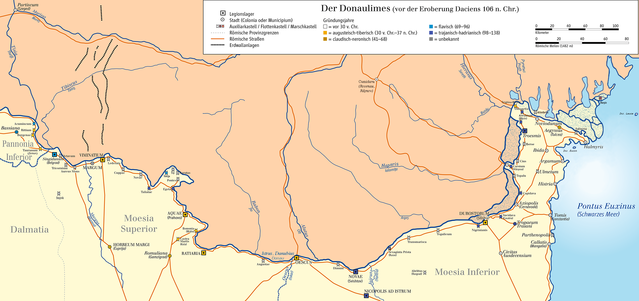
English: Map of Limes in Serbia, Romania and Bulgaria (Donaulimes/system of fortifications representing the boundary of Roman control ; shoreline of the time since Liviu Giosan, et al., “Young Danube delta documents stable Black Sea level since the middle Holocene: Morphodynamic, paleogeographic, and archaeological implications.” Geology 34.9 (2006), 757-760 and “Early Anthropogenic Transformation of the Danube-Black Sea System”, Scientific Reports 2 (2012), 10.1038/srep00582; Luminiţa Preoteasa, et al., “Coastal changes from open coast to present lagoon system in Histria region (Danube Delta).” Journal of Coastal Research 65 (2013), 564-569; Filip Florin, Liviu Giosan, “Evolution of Chilia lobes of the Danube delta: Reorganization of deltaic processes under cultural pressures”. Anthropocene 5 (2014), 65–70; Guénaëlle Bony, et al., “History and influence of the Danube delta lobes on the evolution of the ancient harbour of Orgame (Dobrogea, Romania)”. Journal of Archaeological Science 61 (2015), 186-203; Luminiţa Preoteasa, et al., “The evolution of an asymmetric deltaic lobe (Sf. Gheorghe, Danube) in association with cyclic development of the river-mouth bar: Long-term pattern and present adaptations to human-induced sediment depletion”, Geomorphology 253 (2016), 59–73.
Deutsch: Karte des Donaulimes in Serbien, Rumänien und Bulgarien. Suchbegriffe (Auswahl): Partiscum (Szeged), Tisia (Theiss), Tibiscus (Timis), Mures, Bassiana, Pannonia Inferior, Acumincum, Rittium, Burgenae, Taurunum (Zemun), Sigidunum (Belgrad), Octavum, Tricornium, Aureus Mons, Dalmatia, Viminatium, Lederata, Cuppae, Novae, Taliatae, Moesia Superior, Horreum Magri (Cuprijaa), Novae, Taliatae, Tekija, Sip, Karatas, Pontes, Egeta, Aquae (Prahovo), Bononia (Widin), Castra Martis (Kula), Ratiaria, Romuliana (Gamzigrad), Rabon (Jiu), Alutus (Olt), Oescus, Augustae, Oescus (Iskar), Dimum, Novae (Swishtow), Jairus (Yantra), Naparis (Ialomita), Moesia Inferior, Durostorum (Silistra), Sucidava (Celei), Pontus Euxinus (Schwarzes Meer), Tropaeum Traiani (Adamclisi), Parthenopolis (Movila), Callatis (Mangalia), Civitas Ausdecensium, Histria, Axiopolis (Cernavoda), Ulmetum, Argamum (Iancina), Troesmis, Cius, Carsium (Hârsova), Topalu, Noviodunum, Aegyssus (Tulcea), Salsovia (Mahmudia), Halmyris (Fundeni), Buzau, Hyerasus (Sereth), Pyretus (Pruth), Moldavia (Moldau) |
| Date | |
| Source | Own work/Source of Information: Putzger – Historischer Weltatlas, 89. Auflage, 1965; Westermanns Großer Atlas zur Weltgeschichte, 1978; |
| Author | Ziegelbrenner |
Licensing
I, the copyright holder of this work, hereby publish it under the following licenses:

|
Permission is granted to copy, distribute and/or modify this document under the terms of the GNU Free Documentation License, Version 1.2 or any later version published by the Free Software Foundation; with no Invariant Sections, no Front-Cover Texts, and no Back-Cover Texts. A copy of the license is included in the section entitled GNU Free Documentation License. |
This file is licensed under the Creative Commons Attribution-Share Alike 3.0 Unported, 2.5 Generic, 2.0 Generic and 1.0 Generic license.
- You are free:
- to share – to copy, distribute and transmit the work
- to remix – to adapt the work
- Under the following conditions:
- attribution – You must give appropriate credit, provide a link to the license, and indicate if changes were made. You may do so in any reasonable manner, but not in any way that suggests the licensor endorses you or your use.
- share alike – If you remix, transform, or build upon the material, you must distribute your contributions under the same or compatible license as the original.
You may select the license of your choice.

|
This map has been made or improved in the German Kartenwerkstatt (Map Lab). You can propose maps to improve as well.
|
File history
Click on a date/time to view the file as it appeared at that time.
| Date/Time | Thumbnail | Dimensions | User | Comment | |
|---|---|---|---|---|---|
| current | 14:12, 13 April 2018 | | 2,509 × 1,181 (908 KB) | Julieta39 | Little anachronism about Ialomita : Herodotus said Naparis (Helibacia is cited by Simocatta, centuries later) |
| 12:00, 13 April 2018 |  | 2,509 × 1,181 (908 KB) | Julieta39 | See discussion page please. | |
| 14:37, 28 April 2014 |  | 2,509 × 1,181 (853 KB) | Ziegelbrenner | 2014-04-28 | |
| 14:13, 6 February 2013 |  | 2,953 × 1,390 (579 KB) | Ziegelbrenner | 2013-02-06 | |
| 12:32, 14 November 2011 |  | 1,575 × 787 (269 KB) | Ziegelbrenner | 2011-11-14 | |
| 11:13, 28 January 2011 |  | 2,510 × 1,181 (838 KB) | Ziegelbrenner | 2011-01-28 | |
| 11:43, 26 January 2011 |  | 2,363 × 1,113 (769 KB) | Ziegelbrenner | 2011-01-26 | |
| 11:41, 26 January 2011 |  | 3,765 × 1,772 (1.44 MB) | Ziegelbrenner | Reverted to version as of 14:17, 20 January 2011 | |
| 11:38, 26 January 2011 |  | 7,252 × 3,414 (2.12 MB) | Ziegelbrenner | 2011-01-26 | |
| 14:17, 20 January 2011 |  | 3,765 × 1,772 (1.44 MB) | Ziegelbrenner | 2011-01-20 |
File usage
The following pages on the English Wikipedia use this file (pages on other projects are not listed):
Global file usage
The following other wikis use this file:
- Usage on bg.wikipedia.org
- Usage on ca.wikipedia.org
- Usage on cs.wikipedia.org
- Usage on cy.wikipedia.org
- Usage on de.wikipedia.org
- Abrittus
- Moesia
- Limes (Grenzwall)
- Donaulimes
- Moesia inferior
- Kastell Iatrus
- Wikipedia:Redaktion Altertum/Römischer Limes
- Wikipedia:Redaktion Altertum/Römischer Limes/Pictothek
- Wikipedia Diskussion:Redaktion Altertum/Römischer Limes/Archiv/2010
- Classis Pannonica
- Wikipedia:Kartenwerkstatt/Archiv/2011-01
- Benutzer Diskussion:Ziegelbrenner/Archiv 2011
- Benutzer:Ziegelbrenner/Meine Bilder auf Commons
- Welterbe in Rumänien
- Dux Moesiae primae
- Dux Daciae ripensis
- Dux Moesiae secundae
- Benutzer:Drekamu/Antike Geographie
- Liste der Kastelle am moesischen Limes
- Usage on eo.wikipedia.org
- Usage on es.wikipedia.org
- Usage on eu.wikipedia.org
- Usage on fa.wikipedia.org
- Usage on fr.wikipedia.org
- Usage on gl.wikipedia.org
- Usage on he.wikipedia.org
- Usage on hr.wikipedia.org
- Usage on it.wikipedia.org
View more global usage of this file.