No higher resolution available.
Lake_Manly_system.png (290 × 315 pixels, file size: 16 KB, MIME type: image/png)
| This is a file from the Wikimedia Commons. Information from its description page there is shown below. Commons is a freely licensed media file repository. You can help. |
| Description |
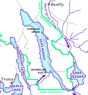
English: The Lake Manly lake system as it might have looked during its last maximum extent 22,000 years ago. (USGS image). The Lake Manly lake system as it might have looked during its last maximum extent 22,000 years ago. Arrows indicate river water flow, gray lines are current highways, and red dots are towns. (USGS image). The Lake Manly lake system as it might have looked during its last maximum extent 22,000 years ago. (USGS image).
Français : Le Lac Manly tel qu'il devait être à son extension maximale, il y a 22 000 années. (Document de l'USGS).
Magyar: A Manly-tó és a környező vízrendszer kb. 22 000 évvel ezelőtt.
Български: Най-вероятно така е изглеждала Долината на смъртта преди 22 000 години. |
|||||||||
| Source |
Death Valley Geology Field Trip: Shoreline Butte: |
|||||||||
| Permission (Reusing this file) |
|
|||||||||
| Geotemporal data | ||||||||||
| Bounding box |
|
|||||||||
| Georeferencing | ||||||||||
| Other versions |
|
|||||||||

File history
Click on a date/time to view the file as it appeared at that time.
| Date/Time | Thumbnail | Dimensions | User | Comment | |
|---|---|---|---|---|---|
| current | 17:43, 23 February 2012 | | 290 × 315 (16 KB) | Ras67 | cropped |
| 08:48, 12 March 2006 |  | 291 × 316 (17 KB) | Urban~commonswiki | USGS image from http://www2.nature.nps.gov/geology/usgsnps/deva/ftsho1.html<br><br>{{PD-USGov}} Category:Death Valley |
File usage
No pages on the English Wikipedia use this file (pages on other projects are not listed).
Global file usage
The following other wikis use this file:
- Usage on bg.wikipedia.org
- Usage on de.wikipedia.org
- Usage on fr.wikipedia.org
- Usage on he.wikipedia.org
- Usage on hu.wikipedia.org
- Usage on it.wikipedia.org
- Usage on zh.wikipedia.org