Lacey_V._Murrow_Bridge_construction.jpg (600 × 473 pixels, file size: 266 KB, MIME type: image/jpeg)
| This is a file from the Wikimedia Commons. Information from its description page there is shown below. Commons is a freely licensed media file repository. You can help. |
|
This is an image of a place or building that is listed on the National Register of Historic Places in the United States of America. Its reference number is 87000866. |
Summary
| Description |
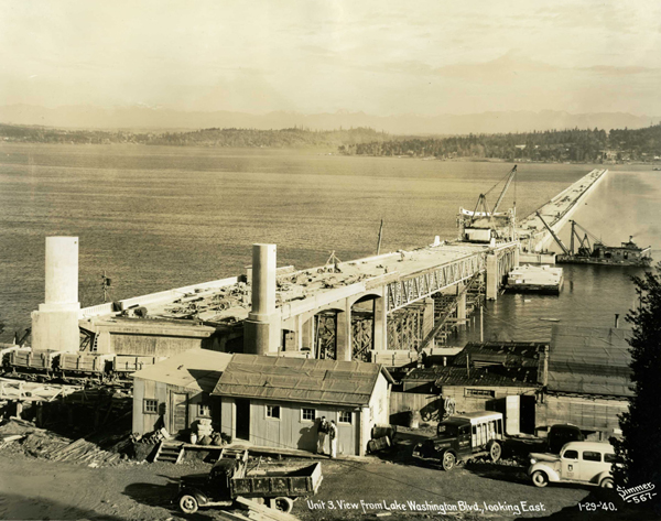
English: Many of the people traveling across one of Lake Washington’s floating bridges likely take the innovative spans for granted, but when the lake’s very first floating bridge opened to traffic on July 2, 1940, it was the culminating moment of a remarkable engineering feat.
Known as the Lacey V. Murrow Bridge, it was the largest and longest floating bridge ever built at that time, and it was the first to be built with reinforced concrete. (It was also known by many as the first I-90 floating bridge.) When it opened, the bridge represented one of “engineering’s greatest triumphs,” in the same category as Boulder Dam and the Golden Gate Bridge. Construction began on the Murrow Bridge on January 1, 1939. This photo, from the Washington State Department of Transportation Photograph Collection, was taken on January 29, 1940, nearly 71 years ago to the day. It was rebuilt after part of the bridge sank on November 25, 1990, with the refurbished bridge opening on September 12, 1993. Construction on a second I-90 floating bridge began in April 1986 and was open to traffic on June 4, 1989. That span is known as the Homer Hadley Bridge. |
| Date | |
| Source | http://blogs.sos.wa.gov/FromOurCorner/index.php/2011/01/building-the-first-lake-washington-floating-bridge/ |
| Author | Washngton State Archives |
| Camera location | | View this and other nearby images on: OpenStreetMap |
|---|
The geographical information in this file was retrospectively estimated.
The location may therefore be somewhat imprecise. Verifying and refining these coordinates is strongly encouraged. |
Licensing
| This work has been released into the public domain by its author, The State of Washington. This applies worldwide. In some countries this may not be legally possible; if so: The State of Washington grants anyone the right to use this work for any purpose, without any conditions, unless such conditions are required by law.
|
File history
Click on a date/time to view the file as it appeared at that time.
| Date/Time | Thumbnail | Dimensions | User | Comment | |
|---|---|---|---|---|---|
| current | 20:10, 12 March 2011 | | 600 × 473 (266 KB) | SchmuckyTheCat~commonswiki | {{Information |Description ={{en|1=Many of the people traveling across one of Lake Washington’s floating bridges likely take the innovative spans for granted, but when the lake’s very first floating bridge opened to traffic on July 2, 1940, it was |
File usage
Global file usage
The following other wikis use this file:
- Usage on es.wikipedia.org