
Size of this PNG preview of this SVG file: 800 × 525 pixels. Other resolutions: 320 × 210 pixels | 640 × 420 pixels | 1,024 × 672 pixels | 1,280 × 840 pixels | 2,560 × 1,680 pixels | 1,839 × 1,207 pixels.
Original file (SVG file, nominally 1,839 × 1,207 pixels, file size: 125 KB)
| This is a file from the Wikimedia Commons. Information from its description page there is shown below. Commons is a freely licensed media file repository. You can help. |
Summary
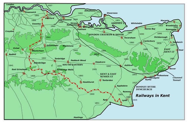
| Description | A map of all the railways in Kent, giving their name and date of construction. Please inform me of errors and omissions via my Talk page. |
| Date | |
| Source |
Own work using:
|
| Author | Clem Rutter, Rochester, Kent. |
| SVG development |
Licensing
I, the copyright holder of this work, hereby publish it under the following licenses:

|
Permission is granted to copy, distribute and/or modify this document under the terms of the GNU Free Documentation License, Version 1.2 or any later version published by the Free Software Foundation; with no Invariant Sections, no Front-Cover Texts, and no Back-Cover Texts. A copy of the license is included in the section entitled GNU Free Documentation License. |
| This file is licensed under the Creative Commons Attribution-Share Alike 3.0 Unported license. | ||
| ||
| This licensing tag was added to this file as part of the GFDL licensing update. |
This file is licensed under the Creative Commons Attribution 2.5 Generic license.
- You are free:
- to share – to copy, distribute and transmit the work
- to remix – to adapt the work
- Under the following conditions:
- attribution – You must give appropriate credit, provide a link to the license, and indicate if changes were made. You may do so in any reasonable manner, but not in any way that suggests the licensor endorses you or your use.
You may select the license of your choice.
Oxted and Dungeness
Mod. 11:31, 23 May 2007 (UTC)
File history
Click on a date/time to view the file as it appeared at that time.
| Date/Time | Thumbnail | Dimensions | User | Comment | |
|---|---|---|---|---|---|
| current | 18:59, 16 August 2015 | | 1,839 × 1,207 (125 KB) | ClemRutter | Added line to Sandgate from Sandling Junction |
| 20:06, 18 November 2007 |  | 1,839 × 1,207 (124 KB) | ClemRutter | Change to HS1 at Stoneness. Taking Gravesend West to the river. | |
| 11:27, 23 May 2007 |  | 1,839 × 1,207 (124 KB) | ClemRutter | == Summary == {{Information |Description=A map of all the railways in Kent, giving their name and date of construction. Inspired by Jessop, Kent History Illustrated, with addition of HS1 in 2003 and 2007. Please inform me of errors and omissions via my Ta | |
| 23:33, 20 May 2007 |  | 1,839 × 1,207 (119 KB) | ClemRutter | {{Information |Description=A map of all the railways in Kent, giving their name and date of construction. Inspited by Jessop, Kent History Illustrated, with addition of HS1 in 2003 and 2007. Please inform me of errors and ommissions via my Talk page. Cons |
File usage
The following pages on the English Wikipedia use this file (pages on other projects are not listed):
- Brasted railway station
- Canterbury and Whitstable Railway
- Chevening Halt railway station
- East Kent Light Railway
- East Kent Railway
- East Kent Railway (heritage)
- Gravesend West Line
- Hawkhurst branch line
- Hoo Peninsula
- London, Chatham and Dover Railway
- Redhill–Tonbridge line
- Romney, Hythe and Dymchurch Railway
- Sheppey Light Railway
- South Eastern Railway (England)
- South Eastern Trains
- South Eastern and Chatham Railway
- Transport in Kent
- Tunnel Railway
- Wealden Line
- Westerham Valley branch line
- Westerham railway station
- Portal:Trains/Did you know/January 2008
Global file usage
The following other wikis use this file:
- Usage on cy.wikipedia.org
- Usage on fa.wikipedia.org
- Usage on fi.wikipedia.org
- Usage on fr.wikipedia.org
- Usage on he.wikipedia.org
- Usage on hu.wikipedia.org
- Usage on it.wikipedia.org
- Usage on ja.wikipedia.org
- Usage on nl.wikipedia.org
- Usage on no.wikipedia.org
- Usage on simple.wikipedia.org
- Usage on si.wikipedia.org