
Size of this JPG preview of this PDF file: 390 × 599 pixels. Other resolutions: 156 × 240 pixels | 313 × 480 pixels | 806 × 1,237 pixels.
Original file (806 × 1,237 pixels, file size: 94 KB, MIME type: application/pdf)
| This is a file from the Wikimedia Commons. Information from its description page there is shown below. Commons is a freely licensed media file repository. You can help. |
Summary
| Description |
English: FAA Published diagram for KITH - Ithaca Tompkins Regional Airport |
| Date | |
| Source | http://aeronav.faa.gov/d-tpp/1805/00779ad.pdf#nameddest=(ITH) |
| Author | US Government - Federal Aviation Administration |
| Camera location | | View this and other nearby images on: OpenStreetMap |
|---|
Airport diagram for Ithaca Tompkins Regional Airport (ITH/KITH) as published April 2018 by the US Federal Aviation Authority
Licensing
This image or file is a work of a Federal Aviation Administration employee, taken or made as part of that person's official duties. As a work of the U.S. federal government, the image is in the public domain in the United States.
|
 |
File history
Click on a date/time to view the file as it appeared at that time.
| Date/Time | Thumbnail | Dimensions | User | Comment | |
|---|---|---|---|---|---|
| current | 15:29, 8 May 2018 | 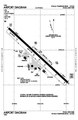 | 806 × 1,237 (94 KB) | Jkstark | User created page with UploadWizard |
File usage
The following pages on the English Wikipedia use this file (pages on other projects are not listed):