
Size of this preview: 400 × 600 pixels. Other resolutions: 160 × 240 pixels | 320 × 480 pixels | 512 × 768 pixels | 682 × 1,024 pixels | 1,365 × 2,048 pixels | 3,500 × 5,250 pixels.
Original file (3,500 × 5,250 pixels, file size: 9.78 MB, MIME type: image/jpeg)
| This is a file from the Wikimedia Commons. Information from its description page there is shown below. Commons is a freely licensed media file repository. You can help. |
Summary
| Description |
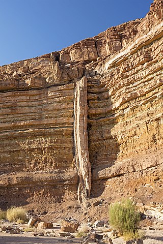
English: Makhtesh Ramon (Ramon crater), located in Israel’s Negev desert, is a 40 km long crater that varies between 2 and 10 km wide, and up to 500 meters deep. Unlike typical impact or volcanic craters, a makhtesh is created by erosion and may be unique to the Negev/Sinai region. Makhtesh Ramon is the largest of the five in the Negev.
The illustration is of a geological dike.
|
||
| Date | |||
| Source | Own work | ||
| Author | Godot13 | ||
| Attribution (required by the license) | Andrew Shiva / Wikipedia / | ||
| Camera location | | View this and other nearby images on: OpenStreetMap |
|---|
Licensing
I, the copyright holder of this work, hereby publish it under the following license:
This file is licensed under the Creative Commons Attribution-Share Alike 4.0 International license.
- You are free:
- to share – to copy, distribute and transmit the work
- to remix – to adapt the work
- Under the following conditions:
- attribution – You must give appropriate credit, provide a link to the license, and indicate if changes were made. You may do so in any reasonable manner, but not in any way that suggests the licensor endorses you or your use.
- share alike – If you remix, transform, or build upon the material, you must distribute your contributions under the same or compatible license as the original.

|
The copyright holder of this file, Andrew Shiva, allows anyone to use it for any purpose, provided that the copyright holder is properly attributed. Redistribution, derivative work, commercial use, and all other use is permitted. |
Attribution:
Use or reproduction of this image outside of Wikipedia must give the original photographer (Andrew Shiva) credit. Although not required, it would be appreciated if a message was left here indicating where this image was being used.
|

|
This image was uploaded as part of Wiki Loves Monuments 2016.
|
 |
This image has been assessed using the Quality image guidelines and is considered a Quality image.
|
File history
Click on a date/time to view the file as it appeared at that time.
| Date/Time | Thumbnail | Dimensions | User | Comment | |
|---|---|---|---|---|---|
| current | 03:58, 12 October 2016 | | 3,500 × 5,250 (9.78 MB) | Godot13 | User created page with UploadWizard |
File usage
The following pages on the English Wikipedia use this file (pages on other projects are not listed):
Global file usage
The following other wikis use this file:
- Usage on bn.wikipedia.org
- Usage on eu.wikipedia.org
- Usage on ja.wikipedia.org
- Usage on sl.wikipedia.org