
Size of this PNG preview of this SVG file: 509 × 299 pixels. Other resolutions: 320 × 188 pixels | 640 × 376 pixels | 1,024 × 602 pixels | 1,280 × 752 pixels | 2,560 × 1,504 pixels.
Original file (SVG file, nominally 509 × 299 pixels, file size: 403 KB)
| This is a file from the Wikimedia Commons. Information from its description page there is shown below. Commons is a freely licensed media file repository. You can help. |
Summary
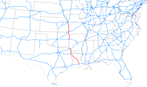
| Description | Map of Interstate 49 as of 2014-12-31 highlighted in red, overall location within southeastern United States. |
| Date | |
| Source |
Map based on File:Map of current Interstates.svg (Public domain) modified to include recent Interstate additions, route of I-49 georeferenced from KML file in article This W3C-unspecified vector image was created with Inkscape . |
| Author | Mr. Matté (if there is an issue with this image, contact me using this image's Commons talk page, my Commons user talk page, or my English Wikipedia user talk page; I'll know about it a lot faster) |
Licensing
| I, the copyright holder of this work, release this work into the public domain. This applies worldwide. In some countries this may not be legally possible; if so: I grant anyone the right to use this work for any purpose, without any conditions, unless such conditions are required by law. |
File history
Click on a date/time to view the file as it appeared at that time.
| Date/Time | Thumbnail | Dimensions | User | Comment | |
|---|---|---|---|---|---|
| current | 22:28, 28 November 2015 | | 509 × 299 (403 KB) | BasilLeaf | Expansion projects and proposals added |
| 22:28, 28 November 2015 |  | 509 × 299 (403 KB) | BasilLeaf | Expansion projects and proposals added | |
| 17:40, 31 December 2014 |  | 509 × 299 (408 KB) | Mr. Matté | =={{int:filedesc}}== {{Information |Description=Map of en:Interstate 49 as of 2014-12-31 highlighted in red, overall location within southeastern United States. |Source=Map based on File:Map of current Interstates.svg (Public domain) modifie... |
File usage
No pages on the English Wikipedia use this file (pages on other projects are not listed).
Global file usage
The following other wikis use this file:
- Usage on fr.wikipedia.org
- Usage on www.wikidata.org