No higher resolution available.
Holland_Arms_Station_-_Pentre_Berw_-_geograph.org.uk_-_1443882.jpg (640 × 480 pixels, file size: 99 KB, MIME type: image/jpeg)
| This is a file from the Wikimedia Commons. Information from its description page there is shown below. Commons is a freely licensed media file repository. You can help. |
Summary
| Description |
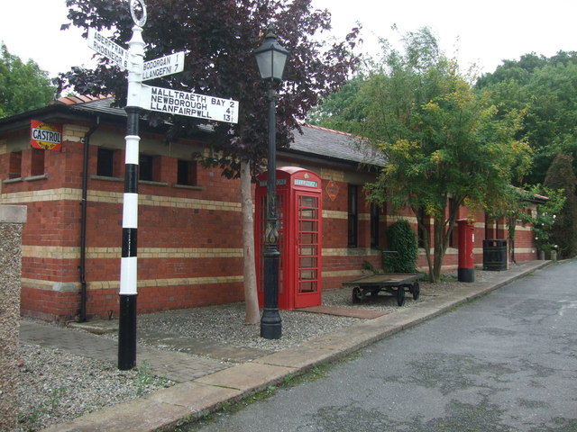
English: Holland Arms Station - Pentre Berw Closed in 1952 this station served Pentre Berw on Anglesey Central Railway which ran from Gaerwen to Amlwch. Note the original signage -John Bull Tyres and Castrol. (Hovis was also there.)
It is on private land and has been restored by the owner.There is an old photograph of the station in use on a BBC TV site devoted to the Red Wharf Bay railway at page 5 http://www.bbc.co.uk/wales/northwest/sites/history/pages/redwharf2.shtml?5. |
| Date | |
| Source | From geograph.org.uk |
| Author | Richard Hoare |
| Attribution (required by the license) | Richard Hoare / Holland Arms Station - Pentre Berw / |
| Camera location | | View this and other nearby images on: OpenStreetMap |
|---|
_heading:157.00&language=en)
| Object location | | View this and other nearby images on: OpenStreetMap |
|---|
_heading:157.00&language=en)
Licensing

|
This image was taken from the Geograph project collection. See this photograph's page on the Geograph website for the photographer's contact details. The copyright on this image is owned by Richard Hoare and is licensed for reuse under the Creative Commons Attribution-ShareAlike 2.0 license.
|
This file is licensed under the Creative Commons Attribution-Share Alike 2.0 Generic license.
Attribution: Richard Hoare
- You are free:
- to share – to copy, distribute and transmit the work
- to remix – to adapt the work
- Under the following conditions:
- attribution – You must give appropriate credit, provide a link to the license, and indicate if changes were made. You may do so in any reasonable manner, but not in any way that suggests the licensor endorses you or your use.
- share alike – If you remix, transform, or build upon the material, you must distribute your contributions under the same or compatible license as the original.
File history
Click on a date/time to view the file as it appeared at that time.
| Date/Time | Thumbnail | Dimensions | User | Comment | |
|---|---|---|---|---|---|
| current | 02:12, 2 March 2011 | | 640 × 480 (99 KB) | GeographBot | == {{int:filedesc}} == {{Information |description={{en|1=Holland Arms Station - Pentre Berw Closed in 1952 this station served Pentre Berw on Anglesey Central Railway which ran from Gaerwen to Amlwch. Note the original signage -John Bull Tyres and Castrol |
File usage
The following pages on the English Wikipedia use this file (pages on other projects are not listed):
Global file usage
The following other wikis use this file:
- Usage on arz.wikipedia.org
- Usage on cy.wikipedia.org
- Usage on www.wikidata.org