
Original file (5,130 × 4,203 pixels, file size: 6.15 MB, MIME type: image/jpeg)
| This is a file from the Wikimedia Commons. Information from its description page there is shown below. Commons is a freely licensed media file repository. You can help. |
Summary
| Description |
Afrikaans: Riviermondings aan die kuslyn van Guinee-Bissau herinner aan 'n vertakte netwerk van plantwortels, en die riviere kronkel langsamerhand deur die land se laelandvlaktes om eindelik in die Atlantiese Oseaan uit te mond. Op pad daarheen karwei hulle water, voedingstowwe, maar ook sedimente uit die land. Hierdie beeld in natuurlike kleur vang die beweging van sedimente vas namate die rivierwaters weswaarts vloei. Die beeld is op 17 Mei 2018 deur Landsat 8 se Operasionele Landafbeelder (OLI) verkry. Die water-verkleuring is opmerklikste in die Rio Geba wat by Bissau, die hoofstad, verbyvloei.
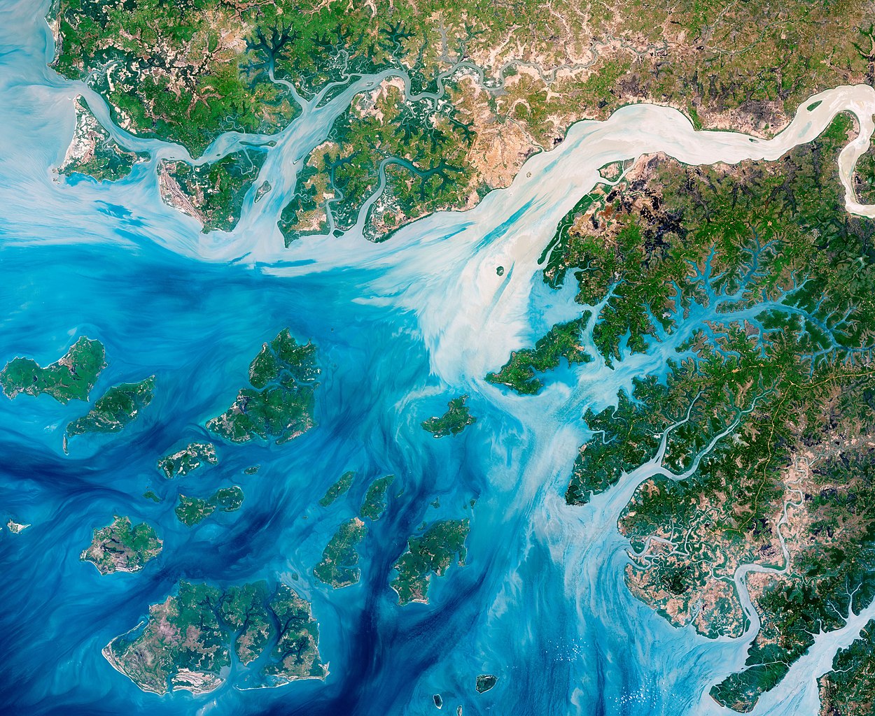
Hierdie riviermondings speel 'n belangrike rol in landbou. Hierdie klein Wes-Afrikaanse land bestaan meestal uit plat terrein wat net 20 tot 30 meter (65 tot 98 voet) bo seevlak staan. Die kusvalleie oorstroom dikwels, veral tydens die reënerigste deel van die jaar (d.i. somer), en kan 'n skadelike uitwerking op infrastruktuur, landbou en openbare gesondheid hê. Die voordelige keersy is egter dat die reën goeie liggings van die valleie vir boerdery, en veral rysverbouing maak. Baie van die landbougrond word deur vernietiging van die mangliet geskep, wat naamlik 'n natuurlike versperring tussen die land en waters vorm. Baie rysproduksie vind byvoorbeeld langs die Rio Geba plaas, wat omring word deur breë valleie en 'n lae, golwende vlakte wat uit die boslande oopgekap is. Gevolglik is kusgebiede geërodeer, wat na verwagting met stygende seevlakke sal vererger. 'n Paar projekte is egter daarop gefokus om mangliet-bevolkings te herstel, en navorsers het tewens hergroei waargeneem.English: Estuaries near the coast of Guinea–Bissau branch out like a network of roots from a plant. With their long tendrils, the rivers meander through the country’s lowland plains to join the Atlantic Ocean. On the way, they carry water, nutrients, but also sediments out from the land. This natural–color image captures the movement of the sediments as the rivers move east to west. The image was acquired on May 17, 2018, by the Operational Land Imager (OLI) on Landsat 8. The discoloration is most apparent in Rio Geba, which runs past the country’s capital city of Bissau.
These estuaries play an important role in agriculture. This small west African country is mostly made up of flat terrain that only stands 20 to 30 meters (65 to 98 feet) above sea level. The coastal valleys flood often, especially during the rainiest part of the year (summer), and can have damaging effects on infrastructure, agriculture, and public health. But at non–devastating levels, the rains make the valleys good locations for farming, especially rice cultivation. Much of the agricultural land is created by destroying mangroves, which act a natural barrier between the land and the water. For instance, a lot of rice production occurs along the Rio Geba, which is surrounded by broad valleys and a low, rolling plain carved out of woodlands. As a result, coastal areas have been eroding, which is expected to worsen with rising sea levels. A few projects are focused on restoring mangrove populations, and researchers have been seeing regrowth.Deutsch: Die Ästuare an der Küste von Guinea-Bissau verzweigen sich wie ein Netzwerk von Wurzeln einer Pflanze. Mit seinen langen Armen mäandrieren die Flüsse durch das Tiefland des Landes auf dem Weg zu ihren Mündungen in den Atlantischen Ozean. Auf ihrem Weg transportieren sie Wasser, Nährstoffe und Sedimente vom Land ins Meer hinaus. Die Photographie in Echtfarben zeigt die Bewegung der Sedimente, während die Flüsse von Osten nach Westen fließen. Die Aufnahme wurde am 17. Mai 2018 mithilfe des Operational Land Imager (OLI) auf dem Satelliten Landsat 8 angefertigt. Die Verfärbung des Wassers ist am deutlichsten sichtbar im Rio Geba, der durch die Landeshauptstadt Bissau fließt.
Diese Ästuare spielen eine wichtige Rolle in der Landwirtschaft. Dieser kleine westafrikanische Staat besteht weitgehend aus flachem Land, das sich nur 20 bis 30 Meter hoch über den Meeresspiegel erhebt. Die Küstengebiete werden häufig überflutet, vor allem während der regenreichsten Zeiten des Jahres im Sommer, mit schädigenden Auswirkugen auf die Infrastruktur, die Landwirtschaft und die öffentliche Gesundheit. Ansonsten machen die Niederschläge die Täler zu gut geeigneten Stellen für die Landwirtschaft, insbesondere den Reisanbau. Ein großer Teil der landwirtschaftlichen Anbauflächen entsteht durch die Zerstörung von Mangroven, die eine natürliche Barriere zwischen Land und Wasser bilden. So liegt ein Großteil der Reisanbauflächen Guinea-Bissaus entlang des Rio Geba, der von flachen Tälern und einer niederen, welligen Ebene umgeben ist, die aus dem Waldland herausgeschnitten wurde. Als Ergebnis davon sind die Küsten erodiert, und der steigende Meeresspiegel wird die Situation verschlimmern. Einige wenige Projekte konzentrieren sich auf die Wiederherstellung der Mangroven, sodass die Wissenschaftler teilweise Neuwachstum beobachtet haben. |
||||||
| Date | |||||||
| Source | https://earthobservatory.nasa.gov/images/92266/the-meandering-estuaries-of-guineabissau | ||||||
| Author | NASA Earth Observatory images by Joshua Stevens, using Landsat data from the U.S. Geological Survey. Story by Kasha Patel. | ||||||
| Other versions |
|
.jpg)
.jpg)
.jpg)
.jpg)
.jpg)
.jpg)
.jpg)

.jpg)
_lrg.jpg)
| Object location | | View this and other nearby images on: OpenStreetMap |
|---|
Assessment
|
References & Resources
- Andrieu, J. (2018) Land cover changes on the West–African coastline from the Saloum Delta (Senegal) to Rio Geba (Guinea–Bissau) between 1979 and 2015. European Journal of Remote Sensing, 51 (1), 314-325.
- European Space Agency (2014, October 1). Guinea–Bissau and the Bissagos Islands. Accessed June 11, 2018.
- NASA Earth Observatory (2016, October 25). Minnesota: Land of the Many–Colored Lakes. Accessed June 11, 2018.
- United Nations Educational, Scientific and Cultural Organization UNESCO (2012, January 30). Coastal erosion major threat to West Africa. Accessed June 11, 2018.
- U.S. Geological Survey The Republic of Guinea–Bissau. Accessed June 11, 2018.
- Wetlands.org (2017, November 8). Restoring mangroves on abandoned rice fields in Guinea–Bissau. Accessed June 13, 2018.
Licensing
| This file is in the public domain in the United States because it was solely created by NASA. NASA copyright policy states that "NASA material is not protected by copyright unless noted". (See Template:PD-USGov, NASA copyright policy page or JPL Image Use Policy.) | ||
 |
Warnings:
|
File history
Click on a date/time to view the file as it appeared at that time.
| Date/Time | Thumbnail | Dimensions | User | Comment | |
|---|---|---|---|---|---|
| current | 18:33, 7 January 2023 | | 5,130 × 4,203 (6.15 MB) | CactiStaccingCrane | brighten imate to clipping point |
| 22:14, 23 December 2019 |  | 5,130 × 4,203 (6.02 MB) | Matthiasb | {{Information |description ={{en|1=Estuaries near the coast of Guinea–Bissau branch out like a network of roots from a plant. With their long tendrils, the rivers meander through the country’s lowland plains to join the Atlantic Ocean. On the way, they carry water, nutrients, but also sediments out from the land. This natural–color image captures the movement of the sediments as the rivers move east to west. The image was acquired on May 17, 2018, by the Operational Land Imager (OLI) on La... |
File usage
Global file usage
The following other wikis use this file:
- Usage on bn.wikipedia.org
- Usage on de.wikipedia.org
- Usage on es.wikipedia.org
- Usage on fr.wikipedia.org
- Usage on pl.wikipedia.org
- Dyskusja wikipedysty:Polinik
- Dyskusja wikipedysty:Malax5
- Dyskusja wikipedysty:P.jucha
- Dyskusja wikipedysty:Gustaw1410
- Dyskusja wikipedysty:Halavar
- Dyskusja wikipedysty:Montignac
- Dyskusja wikipedysty:Mo Cuishle
- Dyskusja wikipedysty:Karbi98
- Dyskusja wikipedysty:Wiroid
- Dyskusja wikipedysty:Stupa1989
- Dyskusja wikipedysty:Panna Wodzianna
- Dyskusja wikipedysty:Dawid Brudniewicz
- Dyskusja wikipedysty:Tolixus
- Dyskusja wikipedysty:Pito22
- Dyskusja wikipedysty:Stvari
- Dyskusja wikipedysty:Gregok
- Dyskusja wikipedysty:Sauron00000
- Dyskusja wikipedysty:Shumkichi
- Dyskusja wikipedysty:OlafMaj1
- Dyskusja wikipedystki:Bialke
- Dyskusja wikipedysty:Mateusz Gieryga/Archiwum/I 2017 – I 2023
- Dyskusja wikipedysty:WrS.tm.pl
- Dyskusja wikipedysty:Patounia
- Dyskusja wikipedysty:Sympathicc
- Dyskusja wikipedysty:Pismaker
- Dyskusja wikipedysty:Komiksomaniak
- Wikipedysta:Skoczny Kacper/Lista zaproszeń
- Dyskusja wikipedystki:Khalisi
- Dyskusja wikipedystki:Rosewood/zaproszeniaTT
- Dyskusja wikipedystki:Soldier of Wasteland
- Dyskusja wikipedysty:Kuba349
- Dyskusja wikipedysty:Pizmaczek11
- Dyskusja wikipedysty:Gruchalo
- Dyskusja wikipedysty:Nawobod/archiwum
- Dyskusja wikipedysty:Nadzik/ZaproszeniaTT
- Dyskusja wikipedysty:Żyrafał/Archiwum7
- Dyskusja wikipedysty:Pitachu
- Dyskusja wikipedysty:Carabus/archiwum6
- Dyskusja wikipedysty:W2k2
- Dyskusja wikipedysty:Patryk2710/Archiwum I
- Dyskusja wikipedysty:Patkro12/Archiwum/3
- Dyskusja wikipedysty:Anonimowy 2/Archiwum 1
View more global usage of this file.