Size of this preview: 685 × 600 pixels. Other resolutions: 274 × 240 pixels | 548 × 480 pixels | 877 × 768 pixels | 1,169 × 1,024 pixels | 2,159 × 1,891 pixels.
Original file (2,159 × 1,891 pixels, file size: 726 KB, MIME type: image/png)
| This is a file from the Wikimedia Commons. Information from its description page there is shown below. Commons is a freely licensed media file repository. You can help. |
| Description |
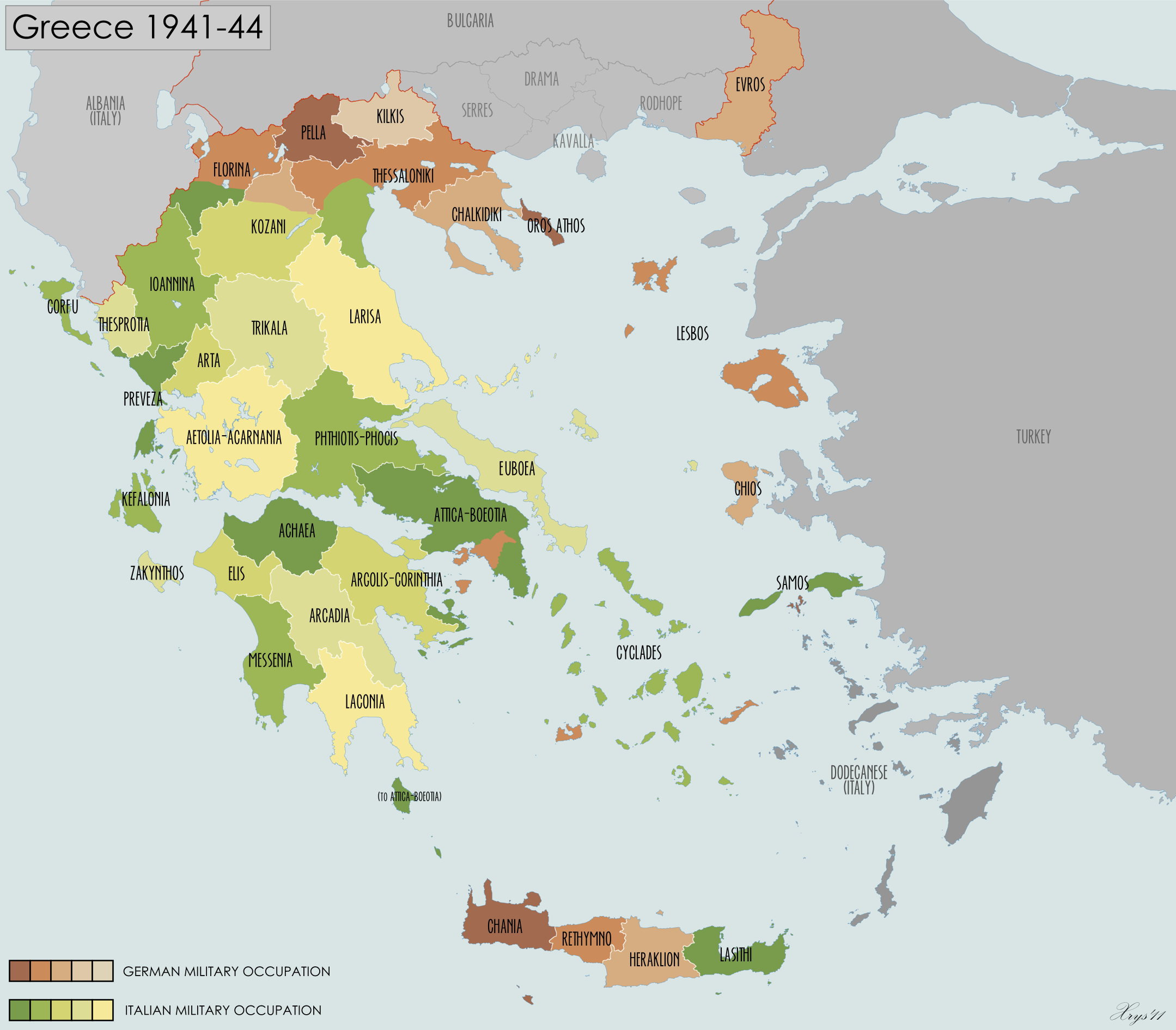
English: Prefectures of Greece under Axis Occupation, 1941-44. Source: Greece political map, 1:1 000 000, 512 Fd. Survey Coy., R.E., 1943. |
| Date | (UTC) |
| Source | |
| Author |
|
I, the copyright holder of this work, hereby publish it under the following license:
This file is licensed under the Creative Commons Attribution-Share Alike 3.0 Unported license.
- You are free:
- to share – to copy, distribute and transmit the work
- to remix – to adapt the work
- Under the following conditions:
- attribution – You must give appropriate credit, provide a link to the license, and indicate if changes were made. You may do so in any reasonable manner, but not in any way that suggests the licensor endorses you or your use.
- share alike – If you remix, transform, or build upon the material, you must distribute your contributions under the same or compatible license as the original.
Original upload log
This image is a derivative work of the following images:
- File:Greece_2011_Periferiakes_Enotites.svg licensed with Cc-by-sa-3.0
- 2010-11-26T21:25:08Z Pitichinaccio 8637x7563 (3208763 Bytes) + "Mykonos"
- 2010-11-21T22:03:05Z Pitichinaccio 8637x7563 (3203644 Bytes) == Summary == {{Information |Description={{en|1=Regional Units of Greece from 2011 (Kallikrates Law), German}} {{de|1=Regionale Einheiten/Bezirke Griechenlands ab 2011 (Kallikrates-Gesetz), deutsch}} |Source={{own}} |Author=[
Uploaded with derivativeFX
File history
Click on a date/time to view the file as it appeared at that time.
| Date/Time | Thumbnail | Dimensions | User | Comment | |
|---|---|---|---|---|---|
| current | 09:14, 10 September 2011 | | 2,159 × 1,891 (726 KB) | XrysD | {{Information |Description={{en|1=Prefectures of Greece under Axis Occupation, 1941-44. Source: Greece political map, 1:1 000 000, 512 Fd. Survey Coy., R.E., 1943.}} |Source=*File:Greece_2011_Periferiakes_Enotites.svg |Date=2011-09-10 09:10 (UTC) |A |
File usage
The following pages on the English Wikipedia use this file (pages on other projects are not listed):
Global file usage
The following other wikis use this file:
- Usage on bg.wikipedia.org
- Usage on bs.wikipedia.org
- Usage on ca.wikipedia.org
- Usage on el.wikipedia.org
- Usage on he.wikipedia.org
- Usage on hu.wikipedia.org
- Usage on it.wikipedia.org
- Usage on ko.wikipedia.org
- Usage on lt.wikipedia.org
- Usage on nl.wikipedia.org
- Usage on pt.wikipedia.org
- Usage on ro.wikipedia.org
- Usage on sh.wikipedia.org
- Usage on sr.wikipedia.org
- Usage on th.wikipedia.org
- Usage on zh.wikipedia.org