.png)
.png&action=edit&redlink=1)
No higher resolution available.
Geologic_map_of_Long_Valley_and_Mono_Basin_region_(USGS).png (300 × 325 pixels, file size: 10 KB, MIME type: image/png)
| This is a file from the Wikimedia Commons. Information from its description page there is shown below. Commons is a freely licensed media file repository. You can help. |
.png)
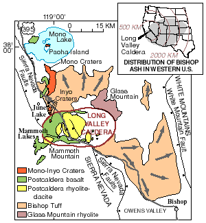
| Description | Geologic map of Long Valley and Mono Basin region | |||
| Date | ||||
| Source | Archived source link | |||
| Author | United States Geological Survey | |||
| Permission (Reusing this file) |
|
File history
Click on a date/time to view the file as it appeared at that time.
| Date/Time | Thumbnail | Dimensions | User | Comment | |
|---|---|---|---|---|---|
| current | 04:31, 20 March 2011 | | 300 × 325 (10 KB) | Hike395 | higher resolution original |
| 18:31, 31 January 2010 |  | 250 × 272 (25 KB) | Mav | {{Information |Description=Geologic map of Long Valley and Mono Basin region |Source={{cite web|url=http://volcanoes.usgs.gov/lvo/about/history.php|title=Geologic History of the Long Valley Caldera and Mono-Inyo Craters Volcanic Chain|publisher=United Sta |
File usage
The following pages on the English Wikipedia use this file (pages on other projects are not listed):
Global file usage
The following other wikis use this file:
- Usage on fr.wikipedia.org
.png)