
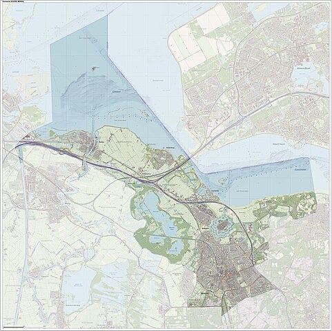
Size of this preview: 601 × 600 pixels. Other resolutions: 240 × 240 pixels | 481 × 480 pixels | 769 × 768 pixels | 1,026 × 1,024 pixels | 2,052 × 2,048 pixels | 5,473 × 5,463 pixels.
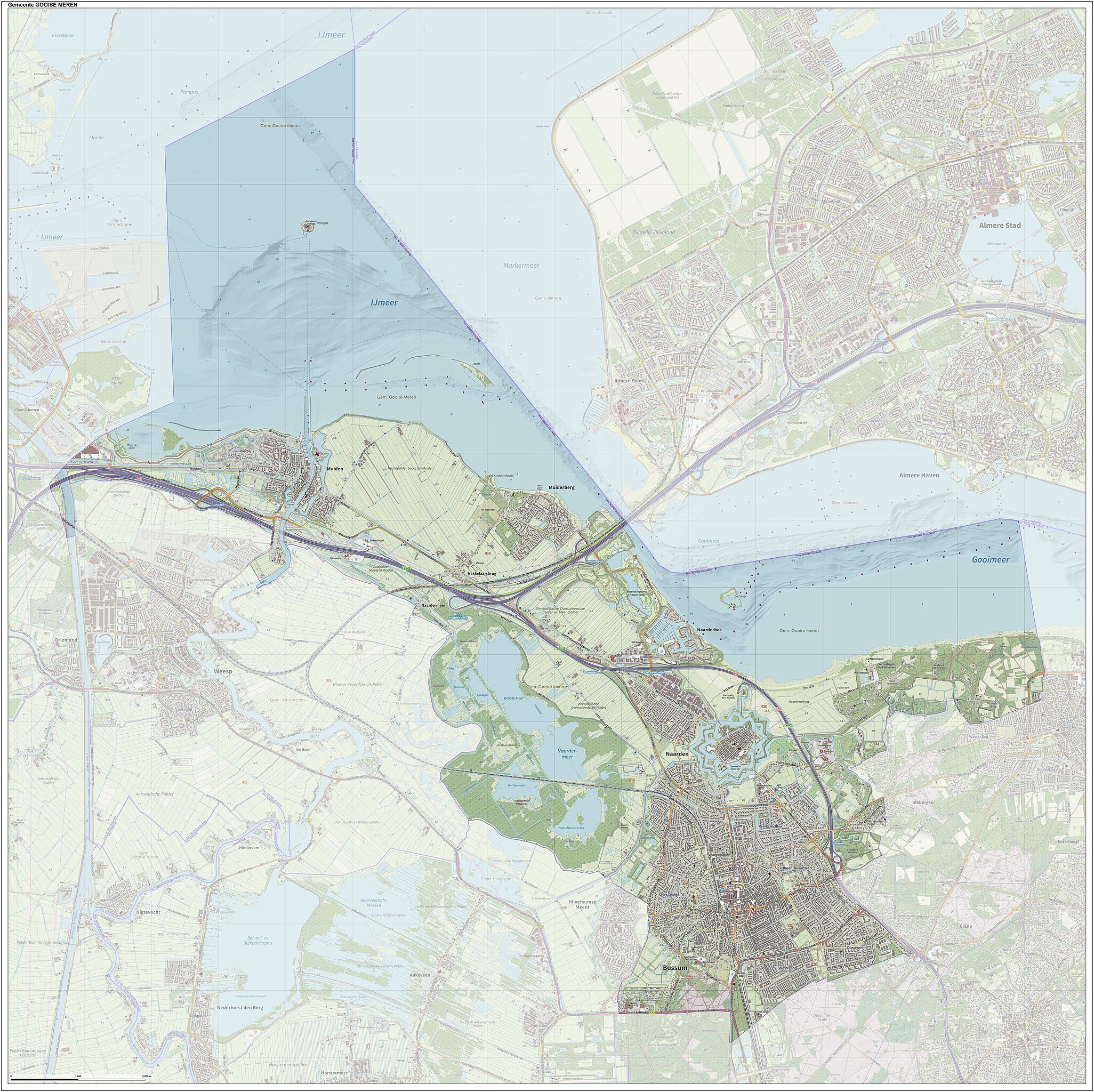
Original file (5,473 × 5,463 pixels, file size: 3.4 MB, MIME type: image/jpeg)
| This is a file from the Wikimedia Commons. Information from its description page there is shown below. Commons is a freely licensed media file repository. You can help. |
Summary
| Description |
Nederlands: Topografische kaart van gemeente Gooise Meren.
Samengesteld door Jan-Willem van Aalst op basis van de GML open geodata van de BRT/Top10NL (basisregistratie Topografie, Kadaster), vrijgegeven door Kadaster onder de Creative Commons BY licentie. Additionele gegevens uit BAG uit de Open Street Map en uit de Risicokaart. Zie ook de Legenda. |
| Date | |
| Source | Own work |
| Author | Janwillemvanaalst |
Licensing
I, the copyright holder of this work, hereby publish it under the following license:
This file is licensed under the Creative Commons Attribution-Share Alike 4.0 International license.
- You are free:
- to share – to copy, distribute and transmit the work
- to remix – to adapt the work
- Under the following conditions:
- attribution – You must give appropriate credit, provide a link to the license, and indicate if changes were made. You may do so in any reasonable manner, but not in any way that suggests the licensor endorses you or your use.
- share alike – If you remix, transform, or build upon the material, you must distribute your contributions under the same or compatible license as the original.
File history
Click on a date/time to view the file as it appeared at that time.
| Date/Time | Thumbnail | Dimensions | User | Comment | |
|---|---|---|---|---|---|
| current | 12:23, 9 July 2023 | | 5,473 × 5,463 (3.4 MB) | Janwillemvanaalst | Map layers update, July 2023 |
| 21:33, 18 September 2022 |  | 6,515 × 6,504 (6.56 MB) | Janwillemvanaalst | Map layers update, September 2022 | |
| 11:59, 6 January 2022 |  | 6,515 × 6,504 (6.6 MB) | Janwillemvanaalst | Map layers update, 1 Jan. 2022 | |
| 23:04, 27 December 2020 |  | 6,519 × 6,512 (6.41 MB) | Janwillemvanaalst | Map layers update, Dec. 2020 | |
| 13:20, 25 July 2020 |  | 6,519 × 6,512 (6.48 MB) | Janwillemvanaalst | Map layers update, 30 June 2020 | |
| 15:25, 25 March 2018 |  | 6,519 × 6,512 (6.42 MB) | Janwillemvanaalst | Map layers update, February 2018 | |
| 21:27, 4 December 2017 |  | 6,519 × 6,512 (6.41 MB) | Janwillemvanaalst | Map layers update, Dec. 2017 | |
| 18:22, 25 May 2017 |  | 6,852 × 6,478 (14.95 MB) | Janwillemvanaalst | Map layers update, April 2017 | |
| 12:25, 19 March 2017 |  | 6,852 × 6,478 (11.26 MB) | Janwillemvanaalst | Map layers update, March 2017 | |
| 10:15, 25 December 2016 |  | 6,852 × 6,478 (15.68 MB) | Janwillemvanaalst | Map layers update, Dec. 2016 |
File usage
The following pages on the English Wikipedia use this file (pages on other projects are not listed):
Global file usage
The following other wikis use this file:
- Usage on ar.wikipedia.org
- Usage on ca.wikipedia.org
- Usage on de.wikipedia.org
- Usage on eo.wikipedia.org
- Usage on fa.wikipedia.org
- Usage on ga.wikipedia.org
- Usage on nl.wikipedia.org
- Usage on ru.wikipedia.org
- Usage on sv.wikipedia.org
- Usage on uk.wikipedia.org
- Usage on www.wikidata.org
- Usage on zea.wikipedia.org