
Size of this PNG preview of this SVG file: 512 × 492 pixels. Other resolutions: 250 × 240 pixels | 500 × 480 pixels | 799 × 768 pixels | 1,066 × 1,024 pixels | 2,131 × 2,048 pixels.
Original file (SVG file, nominally 512 × 492 pixels, file size: 768 KB)
| This is a file from the Wikimedia Commons. Information from its description page there is shown below. Commons is a freely licensed media file repository. You can help. |
| Description |
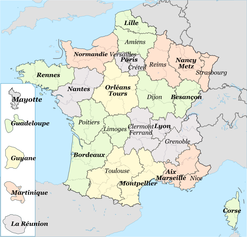
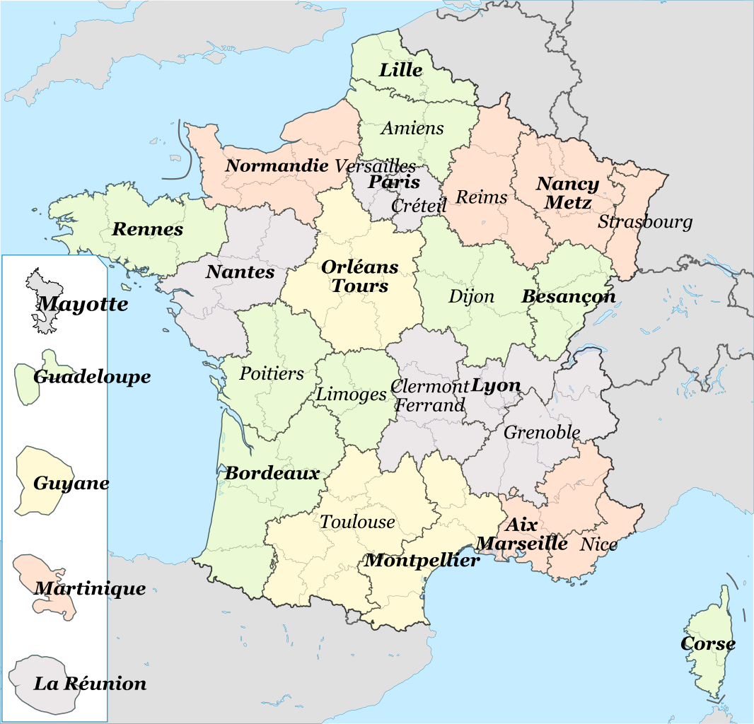
English: A map of the french academies (Mainland only) Français : Les académies de France métropolitaine + DOM |
| Date | (UTC) |
| Source | Data of the map Enseignement_en_France_1.PNG put on the svg base map Régions_de_France.svg |
| Author |
|
This file is licensed under the Creative Commons Attribution-Share Alike 3.0 Unported license.
- You are free:
- to share – to copy, distribute and transmit the work
- to remix – to adapt the work
- Under the following conditions:
- attribution – You must give appropriate credit, provide a link to the license, and indicate if changes were made. You may do so in any reasonable manner, but not in any way that suggests the licensor endorses you or your use.
- share alike – If you remix, transform, or build upon the material, you must distribute your contributions under the same or compatible license as the original.
Original upload log
This image is a derivative work of the following images:
- File:Enseignement_en_France_1.PNG licensed with PD-self
- 2007-02-22T18:44:00Z Babsy 526x556 (42920 Bytes) Carte des académies de France
- File:Régions_de_France.svg licensed with PD-self
- 2010-01-02T18:30:28Z Solsticedhiver 588x550 (459398 Bytes)
- 2010-01-02T15:42:16Z Solsticedhiver 588x550 (459358 Bytes) {{Information |Description={{en|1=a simplified map of french region}} {{fr|1=Les régions de France (version simplifiée)}} |Source=modification of http://fr.wikipedia.org/wiki/Fichier:Départements%2Brégions_(France).svg |A
Uploaded with derivativeFX
File history
Click on a date/time to view the file as it appeared at that time.
| Date/Time | Thumbnail | Dimensions | User | Comment | |
|---|---|---|---|---|---|
| current | 18:27, 15 December 2021 | | 512 × 492 (768 KB) | Ternoc | Ajout de Mayotte |
| 05:40, 8 November 2021 |  | 512 × 492 (760 KB) | Ternoc | Correction mineure | |
| 05:38, 8 November 2021 |  | 512 × 499 (759 KB) | Ternoc | Académie de Normandie | |
| 14:19, 13 December 2015 |  | 2,000 × 1,922 (1.11 MB) | Superbenjamin | Régions et circonscriptions académiques (1er janvier 2016) | |
| 23:18, 7 April 2013 |  | 553 × 584 (479 KB) | Mquinson | * Rename Ajacio to Corse (as it should) * Add several DOM académies (following the approximate geographical scale, to the best of my abilities in inkscape) - Guyane - La réunion - Guadeloupe - Martinique - Mayotte (this one is a "rectorat" ... | |
| 19:59, 4 March 2010 |  | 588 × 550 (235 KB) | Ash Crow | Removed map background... | |
| 19:58, 4 March 2010 |  | 588 × 550 (244 KB) | Ash Crow | Removed map background | |
| 19:46, 3 March 2010 |  | 588 × 550 (253 KB) | Ash Crow | {{Information |Description=== {{en|1=A map of the french academies (Mainland only)}} {{fr|1=Les académies de France métropolitaine}} |Source=*File:Enseignement_en_France_1.PNG *File:Régions_de_France.svg |Date=2010-03-03 19:42 (UTC) |Author |
File usage
The following pages on the English Wikipedia use this file (pages on other projects are not listed):
Global file usage
The following other wikis use this file:
- Usage on fr.wikipedia.org
- Académie (éducation en France)
- Académie de Bordeaux (éducation)
- Académie de Paris
- Académie d'Orléans-Tours
- Académie de Rennes
- Académie de Strasbourg
- Académie d'Amiens (éducation)
- Académie de La Réunion
- Utilisateur:LucasD/Mes images
- Académie de Poitiers
- Académie de Montpellier (éducation)
- Académie de Corse
- Académie d'Aix-Marseille
- Liste des lycées de la région Occitanie
- Académie de Rouen (éducation)
- Académie de Nantes
- Académie de Toulouse
- Académie de Besançon
- Académie de Caen (éducation)
- Académie de Clermont-Ferrand
- Académie de Dijon (éducation)
- Académie de Grenoble
- Académie de Créteil
- Académie de Lyon (éducation)
- Académie de Lille
- Académie de Versailles (éducation)
- Académie de la Guadeloupe
- Académie de Nancy-Metz
- Académie de Nice
- Académie de Limoges
- Académie de Reims
- Académie de Martinique
- Académie de Guyane
- Modèle:Palette Académies françaises
- Académie des Antilles et de la Guyane
- Numéro d'identification éducation nationale
- Académie de Bourges
- Utilisatrice:Ternoc
- Lycée Robert-Schuman (homonymie)
- Utilisateur:LucasD/Brouillon/Images à trier
- Académie de Mayotte
- Académie de Normandie
- Usage on ru.wikipedia.org
- Usage on zh.wikipedia.org