File:Fort DeRussy — Topographical map, 1st Brigade, defenses north of Potomac, Washington, D.C. (West).jpg
No higher resolution available.
Fort_DeRussy_—_Topographical_map,_1st_Brigade,_defenses_north_of_Potomac,_Washington,_D.C._(West).jpg (510 × 413 pixels, file size: 32 KB, MIME type: image/jpeg)
| This is a file from the Wikimedia Commons. Information from its description page there is shown below. Commons is a freely licensed media file repository. You can help. |
Summary
| Description |
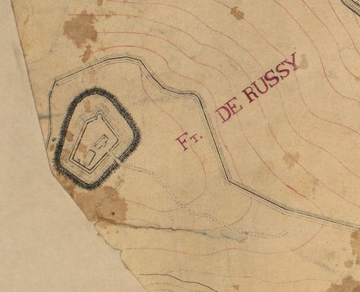
English: "1st September 1863." Relief shown by contours. Some buildings, lot lines, householders' names, forts, and vegetation. Covers environs of Forts De Russy, Stevens, Slocum, Totten, Slemmer, Bunker Hill, Saratoga, Thayer, Lincoln, and Batteries Sill and Jameson. India and red inks. Lacking edge and internal sections, assembled to 1 sheet, sectioned to 4 sheets, and mounted on cloth backing. Includes notes and 2 scale graphs. "189. L. sheet 1." LC Civil War maps (2nd ed.) 680 Available also through the Library of Congress Web site as a raster image. Vault DCP |
||
| Title | Topographical map, 1st Brigade, defenses north of Potomac, Washington, D.C. | ||
| Shelf ID | G3851.S5 1863 .H61 | ||
| Date | |||
| Source | www.loc.gov/resource/g3851s.cw068000w/ | ||
| Author | Hodasevich, R. A. | ||
| Permission (Reusing this file) |
|
||
| Other versions | |||
| Location | United States · Washington D.C. · District Of Columbia · Washington | ||
| Part of | Military Battles And Campaigns · American Memory · Civil War Maps · Catalog · Geography And Map Division | ||
| Subject | Washington (D.C.) · Maps, Topographic · Fortification · Washington · Civil War · United States · Maps · District Of Columbia · Real Property · Manuscript Maps · History |

.jpg)
.jpg)
.jpg&action=edit&redlink=1)
.jpg)
Licensing
This work is in the public domain in the United States because it is a work prepared by an officer or employee of the United States Government as part of that person’s official duties under the terms of Title 17, Chapter 1, Section 105 of the US Code.
Note: This only applies to original works of the Federal Government and not to the work of any individual U.S. state, territory, commonwealth, county, municipality, or any other subdivision. This template also does not apply to postage stamp designs published by the United States Postal Service since 1978. (See § 313.6(C)(1) of Compendium of U.S. Copyright Office Practices). It also does not apply to certain US coins; see The US Mint Terms of Use.
|
 | |
| This file has been identified as being free of known restrictions under copyright law, including all related and neighboring rights. | ||
File history
Click on a date/time to view the file as it appeared at that time.
| Date/Time | Thumbnail | Dimensions | User | Comment | |
|---|---|---|---|---|---|
| current | 11:48, 15 November 2019 | | 510 × 413 (32 KB) | Dcflyer | File:Topographical map, 1st Brigade, defenses north of Potomac, Washington, D.C. (West).jpg cropped 92 % horizontally, 91 % vertically using CropTool with lossless mode. |
.jpg)
File usage
The following pages on the English Wikipedia use this file (pages on other projects are not listed):
.jpg)