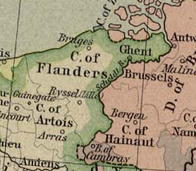
Flandern_1477.png (278 × 242 pixels, file size: 127 KB, MIME type: image/png)
| This is a file from the Wikimedia Commons. Information from its description page there is shown below. Commons is a freely licensed media file repository. You can help. |
Summary
| Description |
English: This map come from the map collection of University of Texas, specifically from: Central Europe in 1477, from Historical Atlas by William R. Shepherd, 1926. It is in the public domain (http://www.lib.utexas.edu/maps/faq.html#3.html).
Deutsch: Diese Karte stammt aus Kartensammlung der University of Texas, speziell von: Central Europe in 1477, aus Historical Atlas von William R. Shepherd, 1926. Sie ist öffentlich freigegeben (http://www.lib.utexas.edu/maps/faq.html#3.html).
Français : Cette carte est issue issu de la collection de cartes de l'université du Texas et plus précisément de celle-ci : Central Europe in 1477, from Historical Atlas by William R. Shepherd, 1926. Elle se trouve dans dans le domaine public (http://www.lib.utexas.edu/maps/faq.html#3.html).
Nederlands: Deze afbeelding is afkomstig uit de kaartencollectie van de University of Texas. Deze kaarten bevinden zich in het publiek domein (http://www.lib.utexas.edu/maps/faq.html#3.html). |
| Date | |
| Source | Historical Atlas von William R. Shepherd, 1926 |
| Author | William R. Shepherd |
Licensing
|
This work is in the public domain in its country of origin and other countries and areas where the copyright term is the author's life plus 70 years or fewer.
| |
| This file has been identified as being free of known restrictions under copyright law, including all related and neighboring rights. | |
File history
Click on a date/time to view the file as it appeared at that time.
| Date/Time | Thumbnail | Dimensions | User | Comment | |
|---|---|---|---|---|---|
| current | 13:00, 6 February 2016 | | 278 × 242 (127 KB) | Heinrich.Airbus | {{Information |Description ={{en|1=This map come from the map collection of University of Texas, specifically from: Central Europe in 1477, from Historical Atlas by William R. Shepherd, 1926. It is in the public domain (http://www.lib.utexas.edu/map... |
File usage
Global file usage
The following other wikis use this file:
- Usage on de.wikipedia.org
- Usage on sl.wikipedia.org