
Size of this PNG preview of this SVG file: 344 × 599 pixels. Other resolutions: 138 × 240 pixels | 276 × 480 pixels | 441 × 768 pixels | 588 × 1,024 pixels | 1,176 × 2,048 pixels | 1,850 × 3,220 pixels.
Original file (SVG file, nominally 1,850 × 3,220 pixels, file size: 125 KB)
| This is a file from the Wikimedia Commons. Information from its description page there is shown below. Commons is a freely licensed media file repository. You can help. |
Summary
| Description |
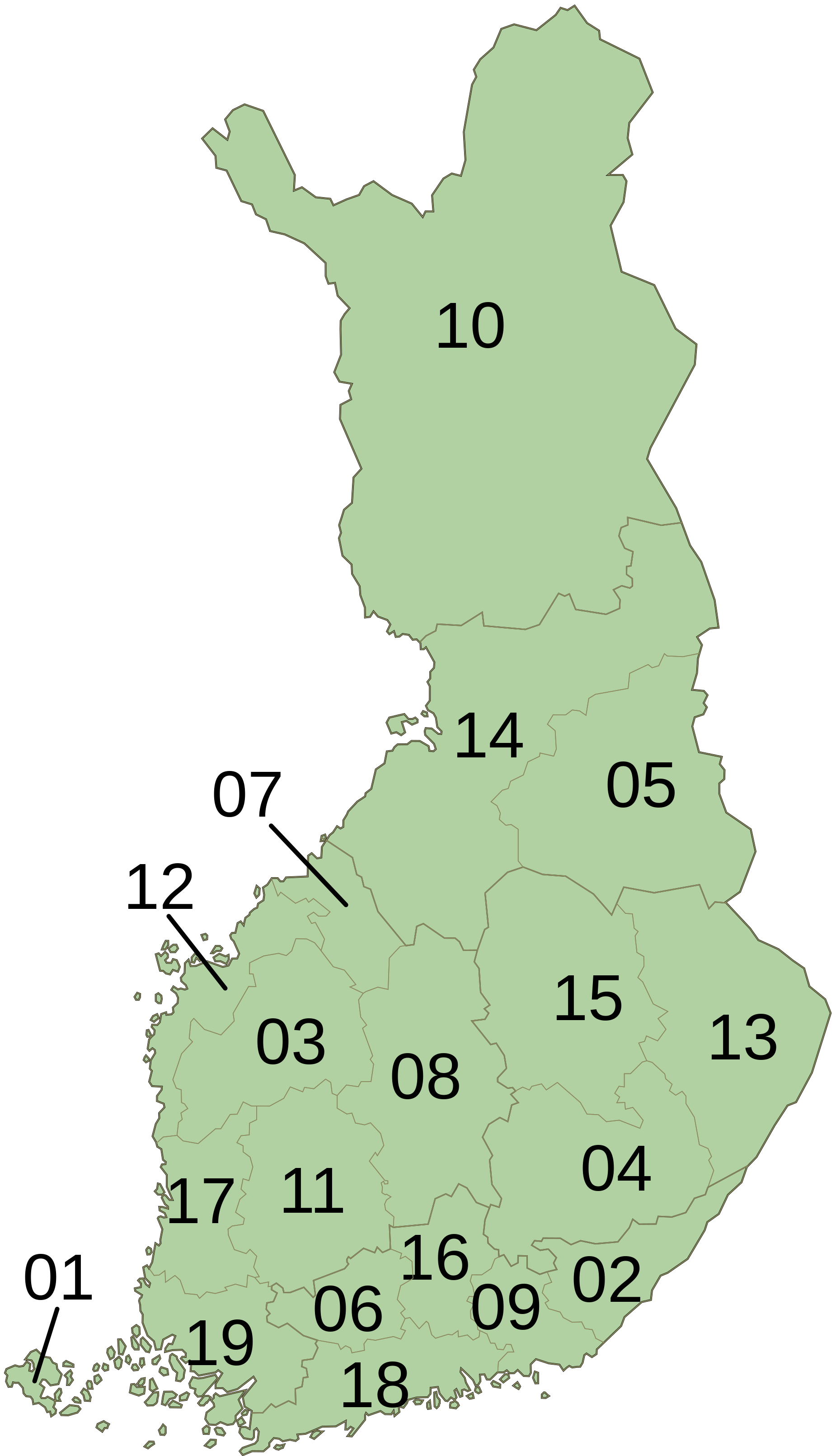
English: Numbered map of Finland divided into its 19 regions. The numbering is based on the ISO 3166-2 subdivision codes.
Suomi: Numeroitu kartta Suomen maakunnista. Numerointi perustuu ISO 3166-2 -standardin mukaisiin koodeihin. |
| Date | 14 April 2012, 10:53 (UTC) |
| Source |
This file was derived from: Finland Regions Map Numbered.svg:  |
| Author |
|
| Other versions |
 |
| This is a retouched picture, which means that it has been digitally altered from its original version. Modifications: Changed numbering to be in accordance with ISO 3166-2.. The original can be viewed here: Finland Regions Map Numbered.svg:
|
Reference
| Number | ISO 3166-2 code | Finnish/Suomi | Swedish/Svenska | English (click link for Category) |
|---|---|---|---|---|
| 01 | FI-01 | Ahvenanmaa | Åland | Åland |
| 02 | FI-02 | Etelä-Karjala | Södra Karelen | South Karelia |
| 03 | FI-03 | Etelä‑Pohjanmaa | Södra Österbotten | Southern Ostrobothnia |
| 04 | FI-04 | Etelä-Savo | Södra Savolax | Southern Savonia |
| 05 | FI-05 | Kainuu | Kajanaland | Kainuu |
| 06 | FI-06 | Kanta-Häme | Egentliga Tavastland | Tavastia Proper |
| 07 | FI-07 | Keski‑Pohjanmaa | Mellersta Österbotten | Central Ostrobothnia |
| 08 | FI-08 | Keski-Suomi | Mellersta Finland | Central Finland |
| 09 | FI-09 | Kymenlaakso | Kymmenedalen | Kymenlaakso |
| 10 | FI-10 | Lappi | Lappland | Lapland |
| 11 | FI-11 | Pirkanmaa | Birkaland | Pirkanmaa |
| 12 | FI-12 | Pohjanmaa | Österbotten | Ostrobothnia |
| 13 | FI-13 | Pohjois-Karjala | Norra Karelen | North Karelia |
| 14 | FI-14 | Pohjois‑Pohjanmaa | Norra Österbotten | Northern Ostrobothnia |
| 15 | FI-15 | Pohjois-Savo | Norra Savolax | Northern Savonia |
| 16 | FI-16 | Päijät-Häme | Päijänne Tavastland | Päijänne Tavastia |
| 17 | FI-17 | Satakunta | Satakunda | Satakunta |
| 18 | FI-18 | Uusimaa | Nyland | Uusimaa |
| 19 | FI-19 | Varsinais‑Suomi | Egentliga Finland | Finland Proper |
Licensing
I, the copyright holder of this work, hereby publish it under the following license:
| I, the copyright holder of this work, release this work into the public domain. This applies worldwide. In some countries this may not be legally possible; if so: I grant anyone the right to use this work for any purpose, without any conditions, unless such conditions are required by law. |
Original upload log
This image is a derivative work of the following images:
- File:Finland_Regions_Map_Numbered.svg licensed with PD-self
- 2011-03-27T10:43:09Z Apalsola 1850x3220 (128422 Bytes) {{Information |Description= {{en|1=Numbered map of Finland divided into its 19 regions.}} {{fi|1=Numeroitu kartta Suomen maakunnista}} |Source=*[[:File:Finland_Regions_Map.svg|]] |Date={{ISOdate|2011-03-27 10:41}} (UTC) |Auth
Uploaded with derivativeFX
File history
Click on a date/time to view the file as it appeared at that time.
| Date/Time | Thumbnail | Dimensions | User | Comment | |
|---|---|---|---|---|---|
| current | 10:58, 14 April 2012 | | 1,850 × 3,220 (125 KB) | Apalsola | == {{int:filedesc}} == {{Information |Description= {{en|1=Numbered map of Finland divided into its 19 regions. The numbering is based on the ISO 3166-2 subdivision codes.}} {{fi|1=Numeroitu kartta Suomen maakunnista. Numerointi pe... |
File usage
The following pages on the English Wikipedia use this file (pages on other projects are not listed):
Global file usage
The following other wikis use this file:
- Usage on de.wikipedia.org
- Usage on eo.wikipedia.org
- Usage on es.wikipedia.org
- Usage on fi.wikipedia.org
- Usage on frr.wikipedia.org
- Usage on fr.wikipedia.org
- Usage on hu.wikipedia.org
- Usage on ja.wikipedia.org
- Usage on li.wikipedia.org
- Usage on no.wikipedia.org
- Usage on pl.wikipedia.org
- Usage on pt.wikipedia.org
- Usage on uk.wikipedia.org