
Size of this PNG preview of this SVG file: 800 × 495 pixels. Other resolutions: 320 × 198 pixels | 640 × 396 pixels | 1,024 × 633 pixels | 1,280 × 791 pixels | 2,560 × 1,583 pixels | 959 × 593 pixels.
Original file (SVG file, nominally 959 × 593 pixels, file size: 67 KB)
| This is a file from the Wikimedia Commons. Information from its description page there is shown below. Commons is a freely licensed media file repository. You can help. |
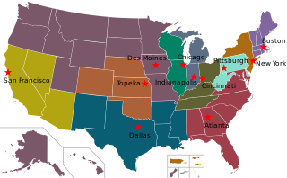
| Description | A map of the United States showing the twelve Federal Home Loan Bank territories and their headquarters. |
| Date | (UTC) |
| Source | |
| Author |
|
This file is licensed under the Creative Commons Attribution-Share Alike 3.0 Unported license.
- You are free:
- to share – to copy, distribute and transmit the work
- to remix – to adapt the work
- Under the following conditions:
- attribution – You must give appropriate credit, provide a link to the license, and indicate if changes were made. You may do so in any reasonable manner, but not in any way that suggests the licensor endorses you or your use.
- share alike – If you remix, transform, or build upon the material, you must distribute your contributions under the same or compatible license as the original.
Original upload log
This image is a derivative work of the following images:
- File:Blank_USA,_w_territories.svg licensed with Cc-by-sa-3.0-migrated, GFDL
- 2009-01-30T01:59:59Z Hoshie 959x593 (98189 Bytes) Reverted to version as of 23:58, 14 January 2009 - rv myself; DC can be seen clearly.
- 2009-01-18T23:34:42Z Hoshie 959x593 (102341 Bytes) Put DC in an inset; fixed Tutuila (American Samoa)
- 2009-01-14T23:58:05Z Lokal Profil 959x593 (98189 Bytes) Code cleanup and removed stroke from Guam and American Samoa
- 2009-01-13T05:19:51Z Hoshie 959x593 (101361 Bytes) re did Guam and added American Samoa
- 2007-12-02T16:08:45Z Lokal Profil 959x593 (88960 Bytes) {{Information |Description=A blank map of the United States including Puerto Rico, Guam, the United States Virgin Islands, and the Northern Mariana Islands. |Source=This version was made by [[:User:Lokal_Profil|Lokal_Profil]]
- File:Red_star.svg licensed with PD-shape
- 2011-02-08T18:58:07Z Sarang 1235x1175 (180 Bytes) more reduced code
- 2010-05-12T01:43:00Z Zscout370 1235x1175 (590 Bytes) Reduced code
- 2008-03-29T10:38:44Z F l a n k e r 1235x1175 (3615 Bytes) Geometries
- 2007-12-26T10:41:31Z Tobias Schmidbauer 190x181 (1478 Bytes) Reverted to version as of 09:44, 27 December 2005
- 2007-03-09T01:37:05Z Indolences 300x275 (350 Bytes)
- 2005-12-27T09:44:56Z Zscout370 190x181 (1478 Bytes) This was drawn by Tobias Schmidbauer.
- 2005-12-26T17:17:09Z Tobias Schmidbauer 190x181 (1473 Bytes) really better version
- 2005-12-24T02:06:13Z Zscout370 300x300 (773 Bytes) A generic red star.
Uploaded with derivativeFX
File history
Click on a date/time to view the file as it appeared at that time.
| Date/Time | Thumbnail | Dimensions | User | Comment | |
|---|---|---|---|---|---|
| current | 06:34, 31 May 2018 | | 959 × 593 (67 KB) | SounderBruce | Updated to reflect merger of Seattle into Des Moines |
| 00:41, 26 April 2011 |  | 959 × 593 (67 KB) | Gurch | test | |
| 00:34, 26 April 2011 |  | 959 × 593 (68 KB) | Gurch | test | |
| 00:04, 26 April 2011 |  | 959 × 593 (69 KB) | Sonia | {{Information |Description=A map of the United States showing the twelve Federal Home Loan Bank territories and their headquarters. |Source=*File:Blank_USA,_w_territories.svg *File:Red_star.svg |Date=2011-04-26 00:02 (UTC) |Author=* |
File usage
The following pages on the English Wikipedia use this file (pages on other projects are not listed):
Global file usage
The following other wikis use this file:
- Usage on ar.wikipedia.org
- Usage on ru.wikipedia.org
- Usage on zh.wikipedia.org