
Size of this preview: 615 × 599 pixels. Other resolutions: 246 × 240 pixels | 493 × 480 pixels | 1,010 × 984 pixels.
Original file (1,010 × 984 pixels, file size: 113 KB, MIME type: image/png)
| This is a file from the Wikimedia Commons. Information from its description page there is shown below. Commons is a freely licensed media file repository. You can help. |
Summary
| Description |
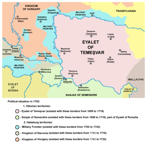
English: map of the Eyalet of Temesvar and Military Frontier in 1702.
Српски / srpski: мапа Темишварског пашалука и војне границе 1702. године. |
| Date | 20 March 2009 (original upload date) |
| Source | No machine-readable source provided. Own work assumed (based on copyright claims). |
| Author | No machine-readable author provided. PANONIAN assumed (based on copyright claims). |
| Other versions | Magyar svg |
References
- The Times History of Europe, Times Books, 2002.
- Školski istorijski atlas, Zavod za izdavanje udžbenika Socijalističke Republike Srbije, Beograd, 1970.
- Milan Tutorov, Banatska rapsodija - istorika Zrenjanina i Banata, Novi Sad, 2001.
- Peter Rokai - Zoltan Đere - Tibor Pal - Aleksandar Kasaš, Istorija Mađara, Beograd, 2002.
- Dr Dušan J. Popović, Srbi u Vojvodini, knjiga 2, Novi Sad, 1990.
- Fridrih Vilhelm fon Taube, Istorijski i geografski opis Kraljevine Slavonije i Vojvodstva Srema, Novi Sad, 1998.
- Miodrag Milin, Vekovima zajedno (Iz istorije srpsko-rumunskih odnosa), Temišvar, 1995.
- Suzana Milovanović, Potiska i pomoriška vojna granica (1702-1751), Novi Sad, 2003.
- Olga Zirojević, Srbija pod turskom vlašću 1459-1804, Beograd, 2007.
- Dr Dušan Popov, Granica i Graničari, Enciklopedija Novog Sada, sveska 6, Novi Sad, 1996.
- Orhan Kılıç, XVII. Yüzyılın İlk Yarısında Osmanlı Devleti'nin Eyalet ve Sancak Teşkilatlanması, Osmanlı, Cilt 6: Teşkilât, Yeni Türkiye Yayınları, Ankara, 1999.
- http://www.historiografija.hr/hz/1957/HZ_10_22_MATKOVIC.pdf archive copy at the Wayback Machine
- [1] - Historijski Zbornik, Том 10, Povijesno društro Hrvatske, 1957, page 215. ("da je Smederevski sandžak u razdoblju od 1591 — 1699 bio dio Budimskog pašaluka, od 1699 do 1791 dio Rumelij- skog pašaluka")
Licensing
self made map by user:PANONIAN
| I, the copyright holder of this work, release this work into the public domain. This applies worldwide. In some countries this may not be legally possible; if so: I grant anyone the right to use this work for any purpose, without any conditions, unless such conditions are required by law. |
File history
Click on a date/time to view the file as it appeared at that time.
| Date/Time | Thumbnail | Dimensions | User | Comment | |
|---|---|---|---|---|---|
| current | 21:11, 14 September 2013 | | 1,010 × 984 (113 KB) | PANONIAN | aesthetics |
| 20:20, 5 September 2013 |  | 1,010 × 984 (117 KB) | PANONIAN | corrections | |
| 16:59, 30 September 2011 |  | 1,015 × 984 (117 KB) | PANONIAN | correction | |
| 12:42, 29 September 2011 |  | 1,015 × 984 (117 KB) | PANONIAN | some corrections | |
| 21:04, 22 March 2009 |  | 1,015 × 984 (120 KB) | PANONIAN | ||
| 12:02, 20 March 2009 |  | 1,015 × 936 (121 KB) | PANONIAN | ||
| 02:15, 20 March 2009 |  | 1,015 × 894 (111 KB) | PANONIAN | map of the Eyalet of Temesvar and Military Frontier in 1699 (self made) {{PD-self}} Category:Maps of the history of Romania Category:Maps of the history of Serbia Category:Maps of the history of Vojvodina |
File usage
The following pages on the English Wikipedia use this file (pages on other projects are not listed):
Global file usage
The following other wikis use this file:
- Usage on da.wikipedia.org
- Usage on de.wikipedia.org
- Usage on el.wikipedia.org
- Usage on et.wikipedia.org
- Usage on fa.wikipedia.org
- Usage on gl.wikipedia.org
- Usage on he.wikipedia.org
- Usage on hr.wikipedia.org
- Usage on ja.wikipedia.org
- Usage on lt.wikipedia.org
- Usage on mk.wikipedia.org
- Usage on nn.wikipedia.org
- Usage on no.wikipedia.org
- Usage on pnb.wikipedia.org
- Usage on pt.wikipedia.org
- Usage on ro.wikipedia.org
- Usage on ru.wikipedia.org
- Usage on sh.wikipedia.org
- Usage on sk.wikipedia.org
- Usage on sl.wikipedia.org
- Usage on th.wikipedia.org
- Usage on tr.wikipedia.org
- Usage on tt.wikipedia.org
- Usage on ur.wikipedia.org
- Usage on vi.wikipedia.org