
Size of this preview: 800 × 491 pixels. Other resolutions: 320 × 196 pixels | 640 × 393 pixels | 1,140 × 700 pixels.
Original file (1,140 × 700 pixels, file size: 168 KB, MIME type: image/png)
| This is a file from the Wikimedia Commons. Information from its description page there is shown below. Commons is a freely licensed media file repository. You can help. |
Summary
| Description |
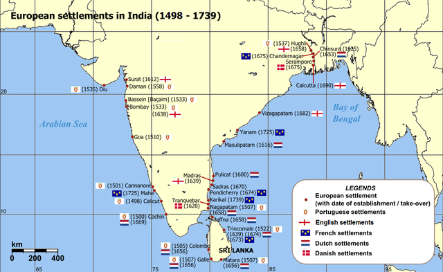
English: Map of India with Sri Lanka, illustrating locations of European settlements in the subcontinent between 1501 and 1739.
Norsk nynorsk: Kart over Sør-Asia med europeiske koloniar/busetjingar mellom 1501 og 1739.
Dansk: Kort af Indien inkl. Sri Lanka med europæiske kolonier mellem 1501 og 1739. |
| Date | uploaded in 2006 |
| Source |
Self-published work by Luis wiki Map reference: [1] at w:University of Pennsylvania, with reference varification from: [2] (URL accessed: 23-Mar-2006) |
| Author | Luis wiki |
| Other versions |
|

![[1]](http://www.history.upenn.edu/coursepages/hist086/material/schmidt26a.jpg)

|
This map of asia image could be re-created using vector graphics as an SVG file. This has several advantages; see Commons:Media for cleanup for more information. If an SVG form of this image is available, please upload it and afterwards replace this template with
{{vector version available|new image name}}.
It is recommended to name the SVG file “European settlements in India 1501-1739.svg”—then the template Vector version available (or Vva) does not need the new image name parameter. |
Licensing
I, the copyright holder of this work, hereby publish it under the following license:
This file is licensed under the Creative Commons Attribution-Share Alike 2.5 Generic license.
- You are free:
- to share – to copy, distribute and transmit the work
- to remix – to adapt the work
- Under the following conditions:
- attribution – You must give appropriate credit, provide a link to the license, and indicate if changes were made. You may do so in any reasonable manner, but not in any way that suggests the licensor endorses you or your use.
- share alike – If you remix, transform, or build upon the material, you must distribute your contributions under the same or compatible license as the original.
File history
Click on a date/time to view the file as it appeared at that time.
| Date/Time | Thumbnail | Dimensions | User | Comment | |
|---|---|---|---|---|---|
| current | 14:47, 12 March 2011 | | 1,140 × 700 (168 KB) | Luis wiki | Bombay, Portuguese from 1534, later on British |
| 22:30, 5 February 2011 |  | 1,140 × 700 (198 KB) | Henry Bottomley~commonswiki | Title date (see Calicut), Goa date, Flags of the time of Portugal, France and England | |
| 20:49, 2 March 2010 |  | 1,140 × 700 (158 KB) | Brianski | Fix spelling of "Portuguese" | |
| 20:34, 22 February 2007 |  | 1,140 × 700 (214 KB) | Wereon | "CE" unnecessary | |
| 12:32, 23 March 2006 |  | 1,140 × 700 (232 KB) | Miljoshi | Map of India with Sri Lanka, illustrating locations of European settlements in the subcontinent between 1501 and 1739 CE. Category:India |
File usage
The following pages on the English Wikipedia use this file (pages on other projects are not listed):
Global file usage
The following other wikis use this file:
- Usage on af.wikipedia.org
- Usage on ar.wikipedia.org
- Usage on ast.wikipedia.org
- Usage on as.wikipedia.org
- Usage on azb.wikipedia.org
- Usage on az.wikipedia.org
- Usage on bn.wikipedia.org
- Usage on br.wikipedia.org
- Usage on ca.wikipedia.org
- Usage on cs.wikipedia.org
- Usage on da.wikipedia.org
- Usage on da.wikibooks.org
- Usage on de.wikipedia.org
- Usage on el.wikipedia.org
- Usage on eo.wikipedia.org
- Usage on es.wikipedia.org
- Usage on et.wikipedia.org
- Usage on fa.wikipedia.org
- Usage on fi.wikipedia.org
View more global usage of this file.