No higher resolution available.
Cow_Castle_Iron_Age_fort,Simonsbath,Somerset._-_geograph.org.uk_-_266665.jpg (640 × 420 pixels, file size: 70 KB, MIME type: image/jpeg)
| This is a file from the Wikimedia Commons. Information from its description page there is shown below. Commons is a freely licensed media file repository. You can help. |
Summary
| Description |
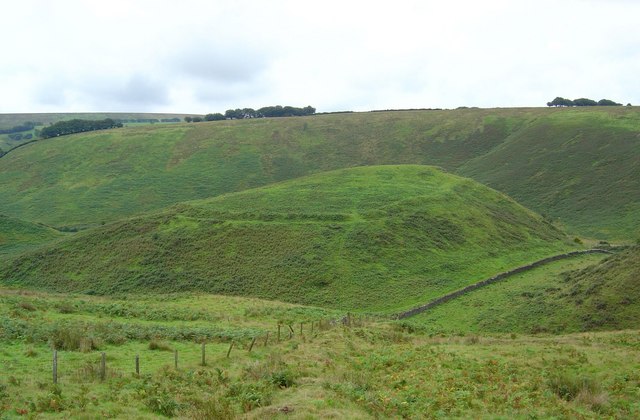
English: Cow Castle Iron Age fort,Simonsbath,Somerset. Situated on an isolated hill overlooking the confluence of the River Barle with the Whitewater.This oval shaped fort is defended by a single stone rampart enclosing an area of about 3 acres.There are possibly two entrances, one on the south-east side and the other at the north-east. |
| Date | |
| Source | From geograph.org.uk |
| Author | Maurice Clements |
| Attribution (required by the license) | Maurice Clements / Cow Castle Iron Age fort,Simonsbath,Somerset. / |
| Camera location | | View this and other nearby images on: OpenStreetMap |
|---|
_heading:292.00&language=en)
| Object location | | View this and other nearby images on: OpenStreetMap |
|---|
_heading:292.00&language=en)
Licensing

|
This image was taken from the Geograph project collection. See this photograph's page on the Geograph website for the photographer's contact details. The copyright on this image is owned by Maurice Clements and is licensed for reuse under the Creative Commons Attribution-ShareAlike 2.0 license.
|
This file is licensed under the Creative Commons Attribution-Share Alike 2.0 Generic license.
Attribution: Maurice Clements
- You are free:
- to share – to copy, distribute and transmit the work
- to remix – to adapt the work
- Under the following conditions:
- attribution – You must give appropriate credit, provide a link to the license, and indicate if changes were made. You may do so in any reasonable manner, but not in any way that suggests the licensor endorses you or your use.
- share alike – If you remix, transform, or build upon the material, you must distribute your contributions under the same or compatible license as the original.
File history
Click on a date/time to view the file as it appeared at that time.
| Date/Time | Thumbnail | Dimensions | User | Comment | |
|---|---|---|---|---|---|
| current | 15:24, 12 December 2010 | | 640 × 420 (70 KB) | GeographBot | == {{int:filedesc}} == {{Information |description={{en|1=Cow Castle Iron Age fort,Simonsbath,Somerset. Situated on an isolated hill overlooking the confluence of the River Barle with the Whitewater.This oval shaped fort is defended by a single stone rampa |
File usage
The following pages on the English Wikipedia use this file (pages on other projects are not listed):
Global file usage
The following other wikis use this file:
- Usage on cy.wikipedia.org
- Usage on www.wikidata.org