
Size of this preview: 800 × 520 pixels. Other resolutions: 320 × 208 pixels | 640 × 416 pixels | 1,024 × 665 pixels | 1,513 × 983 pixels.
Original file (1,513 × 983 pixels, file size: 153 KB, MIME type: image/png)
| This is a file from the Wikimedia Commons. Information from its description page there is shown below. Commons is a freely licensed media file repository. You can help. |
Summary
| Description |
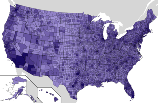
Map of counties in the United States by population. Darker purple counties are more populous. <3,000
3,000-9,999
10,000-19,999
20,000-49,999
50,000-99,999
100,000-199,999
200,000-499,999
500,000-999,999
1,000,000-1,999,999
2,000,000+ |
| Date | |
| Source | Map shapefile from File:Map_of_USA_with_county_outlines_(black_&_white).png, results from 2020 Census data ("Explore Census Data". U.S. Census Bureau. Retrieved March 3, 2021.) |
| Author | Infrarrojo00 |
.png)
Licensing
I, the copyright holder of this work, hereby publish it under the following license:
This file is licensed under the Creative Commons Attribution-Share Alike 4.0 International license.
- You are free:
- to share – to copy, distribute and transmit the work
- to remix – to adapt the work
- Under the following conditions:
- attribution – You must give appropriate credit, provide a link to the license, and indicate if changes were made. You may do so in any reasonable manner, but not in any way that suggests the licensor endorses you or your use.
- share alike – If you remix, transform, or build upon the material, you must distribute your contributions under the same or compatible license as the original.
File history
Click on a date/time to view the file as it appeared at that time.
| Date/Time | Thumbnail | Dimensions | User | Comment | |
|---|---|---|---|---|---|
| current | 21:10, 9 March 2022 | | 1,513 × 983 (153 KB) | Infrarrojo00 | Uploaded own work with UploadWizard |
File usage
No pages on the English Wikipedia use this file (pages on other projects are not listed).
Global file usage
The following other wikis use this file:
- Usage on zh.wikipedia.org