
Original file (1,425 × 625 pixels, file size: 21 KB, MIME type: image/png)
| This is a file from the Wikimedia Commons. Information from its description page there is shown below. Commons is a freely licensed media file repository. You can help. |
| Description |
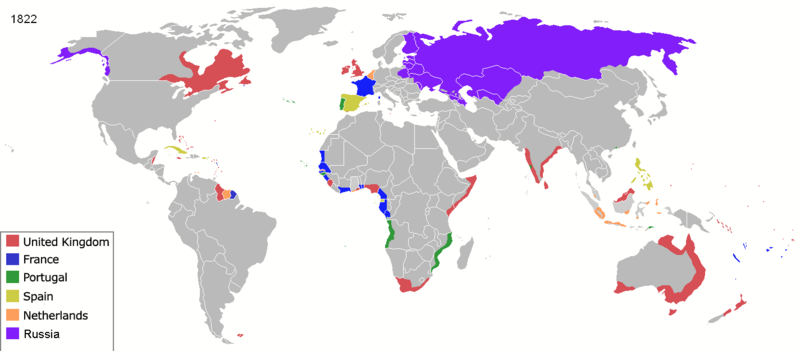
Map of major world powers by year, derived from public domain animated map on wikipedia.
As the orriginal licence of the animation was Public Domain, this image which has been derived from it is too:
|
||||||||||||||||||
| Date | |||||||||||||||||||
| Source | public domain animated map by ArdadN here | ||||||||||||||||||
| Author | ArdadN | ||||||||||||||||||
.jpg)
._LOC_2001620596.jpg)

|
This historical map image could be re-created using vector graphics as an SVG file. This has several advantages; see Commons:Media for cleanup for more information. If an SVG form of this image is available, please upload it and afterwards replace this template with
{{vector version available|new image name}}.
It is recommended to name the SVG file “Colonisation 1822.svg”—then the template Vector version available (or Vva) does not need the new image name parameter. |
| Annotations | This image is annotated: View the annotations at Commons |
File history
Click on a date/time to view the file as it appeared at that time.
| Date/Time | Thumbnail | Dimensions | User | Comment | |
|---|---|---|---|---|---|
| current | 23:57, 17 March 2022 | | 1,425 × 625 (21 KB) | M.Bitton | per https://commons.wikimedia.org/w/index.php?title=Commons:Graphic_Lab/Map_workshop&oldid=640501111#Wrong_borders |
| 12:31, 4 April 2020 |  | 1,425 × 625 (48 KB) | Ориенталист | Azerbaijan was part of Russia since 1813 | |
| 12:13, 4 April 2020 |  | 1,425 × 625 (48 KB) | Devlet Geray | Cherkesses, Chechens, and Dagistani peoples weren't in Russia untill the end of Caucasus War | |
| 05:56, 29 March 2015 |  | 1,425 × 625 (53 KB) | Alvin Lee | Madagascar. See discussion. | |
| 00:32, 3 August 2014 |  | 1,425 × 625 (53 KB) | Alvin Lee | Correcting the boundary of Russia and China | |
| 21:44, 23 January 2011 |  | 1,425 × 625 (77 KB) | Micsha~commonswiki | Reverted to version as of 01:41, 22 May 2010 | |
| 21:43, 23 January 2011 |  | 488 × 313 (66 KB) | Micsha~commonswiki | Africa only; includes map key | |
| 01:41, 22 May 2010 |  | 1,425 × 625 (77 KB) | Kieran4 | Louisiana Purchase | |
| 02:06, 3 May 2010 |  | 1,425 × 625 (77 KB) | Kieran4 | Corrected Dutch East Indies | |
| 10:41, 22 March 2007 |  | 1,425 × 625 (66 KB) | Roke~commonswiki | {{Information |Description=Map of major world powers by year, derived from public domain animated map on wikipedia. {{Maps of world history}} As the orriginal licence of the animation was Public Domain, this image which has been derived from it is too: { |
File usage
Global file usage
The following other wikis use this file:
- Usage on ba.wikipedia.org
- Usage on de.wikipedia.org
- Usage on es.wikipedia.org
- Usage on fa.wikipedia.org
- Usage on fr.wikipedia.org
- Usage on it.wikipedia.org
- Usage on oc.wikipedia.org
- Usage on pt.wikipedia.org
- Usage on ro.wikipedia.org
- Usage on ru.wikipedia.org