
Size of this preview: 800 × 294 pixels. Other resolutions: 320 × 118 pixels | 640 × 235 pixels | 1,409 × 518 pixels.
Original file (1,409 × 518 pixels, file size: 162 KB, MIME type: image/png)
| This is a file from the Wikimedia Commons. Information from its description page there is shown below. Commons is a freely licensed media file repository. You can help. |
Summary
| Camera location | | View this and other nearby images on: OpenStreetMap |
|---|
| Description |
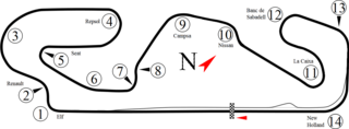
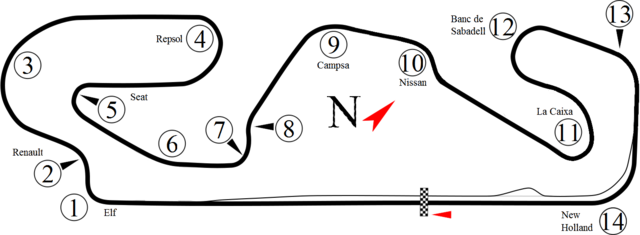
English: Track map for Circuit de Catalunya as used from 1991 to 1994 (4.747 km) Italiano: Mappa del circuito di Catalogna (4,747 km, 1991-1994) |
| Date | |
| Source | Own work, based on Catalunya.svg by Will Pittenger |
| Author | Gpmat |
Licensing
I, the copyright holder of this work, hereby publish it under the following license:
This file is licensed under the Creative Commons Attribution-Share Alike 3.0 Unported license.
- You are free:
- to share – to copy, distribute and transmit the work
- to remix – to adapt the work
- Under the following conditions:
- attribution – You must give appropriate credit, provide a link to the license, and indicate if changes were made. You may do so in any reasonable manner, but not in any way that suggests the licensor endorses you or your use.
- share alike – If you remix, transform, or build upon the material, you must distribute your contributions under the same or compatible license as the original.
File history
Click on a date/time to view the file as it appeared at that time.
| Date/Time | Thumbnail | Dimensions | User | Comment | |
|---|---|---|---|---|---|
| current | 14:50, 2 May 2012 | 1,409 × 518 (162 KB) | Gpmat | Fix error | |
| 14:46, 2 May 2012 | 1,409 × 518 (162 KB) | Gpmat | More details | ||
| 08:40, 2 May 2012 |  | 579 × 696 (31 KB) | Gpmat |
File usage
The following pages on the English Wikipedia use this file (pages on other projects are not listed):
Global file usage
The following other wikis use this file:
- Usage on ar.wikipedia.org
- Usage on ca.wikipedia.org
- Usage on cs.wikipedia.org
- Usage on de.wikipedia.org
- Usage on es.wikipedia.org
- Usage on fi.wikipedia.org
- Usage on fr.wikipedia.org
- Usage on gl.wikipedia.org
- Usage on id.wikipedia.org
- Usage on it.wikipedia.org
- Usage on ja.wikipedia.org
- Usage on ms.wikipedia.org
- Usage on nl.wikipedia.org
- Usage on pl.wikipedia.org
View more global usage of this file.