
Size of this PNG preview of this SVG file: 619 × 600 pixels. Other resolutions: 248 × 240 pixels | 495 × 480 pixels | 793 × 768 pixels | 1,057 × 1,024 pixels | 2,114 × 2,048 pixels.
Original file (SVG file, nominally 800 × 775 pixels, file size: 1.47 MB)
| This is a file from the Wikimedia Commons. Information from its description page there is shown below. Commons is a freely licensed media file repository. You can help. |
Summary
| Description |
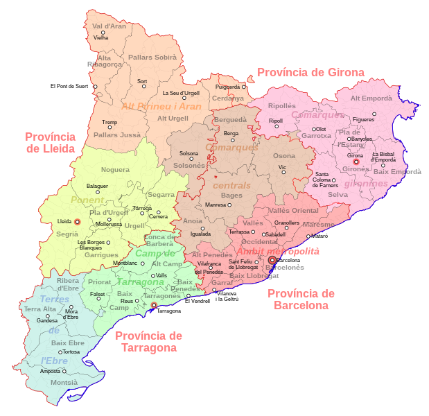
Català: Mapa de l'organització administrativa de Catalunya: assenyalades en vermell, les províncies; en negre, les comarques; en gris, els municipis. Les comarques s'han colorejat d'acord a les agrupacions fetes al Pla territorial general de Catalunya, de 1995. De totes les entitats territorials s'esmenten els noms i les capitals si en tenen. Basat en el Mapa municipal de Catalunya d'Ebrenc.
Español: Mapa de la organización administrativa de Cataluña: bordeadas en rojo, las províncias; en negro, las comarcas; en gris, los municipios. Las comarcas se han coloreado en función de las agrupaciones hechas por el Pla territorial general de Catalunya, de 1995. De todos los territorios se indican los nombres y sus capitales si tienen. Basado en el Mapa municipal de Cataluña de Ebrenc. |
| Date | |
| Source | Own work |
| Author | HansenBCN |
Licensing
I, the copyright holder of this work, hereby publish it under the following license:
This file is licensed under the Creative Commons Attribution-Share Alike 2.5 Generic license.
- You are free:
- to share – to copy, distribute and transmit the work
- to remix – to adapt the work
- Under the following conditions:
- attribution – You must give appropriate credit, provide a link to the license, and indicate if changes were made. You may do so in any reasonable manner, but not in any way that suggests the licensor endorses you or your use.
- share alike – If you remix, transform, or build upon the material, you must distribute your contributions under the same or compatible license as the original.
File history
Click on a date/time to view the file as it appeared at that time.
| Date/Time | Thumbnail | Dimensions | User | Comment | |
|---|---|---|---|---|---|
| current | 15:38, 9 August 2007 | | 800 × 775 (1.47 MB) | HansenBCN | == Summary == {{Information |Description={{ca|Mapa de l'organització administrativa de Catalunya: assenyalades en vermell, les províncies; en negre, les comarques; en gris, els municipis. Les comarques s'han colorejat d'acord a les agrupacions fetes al |
| 15:03, 9 August 2007 |  | 800 × 775 (1.41 MB) | HansenBCN | {{Information |Description={{ca|Mapa de l'organització administrativa de Catalunya: assenyalades en vermell, les províncies; en negre, les comarques; en gris, els municipis. Les comarques s'han colorejat d'acord a les agrupacions fetes al Pla territoria |
File usage
The following pages on the English Wikipedia use this file (pages on other projects are not listed):
Global file usage
The following other wikis use this file:
- Usage on bh.wikipedia.org
- Usage on bn.wikipedia.org
- Usage on br.wikipedia.org
- Usage on bxr.wikipedia.org
- Usage on ca.wikipedia.org
- Usage on ceb.wikipedia.org
- Usage on ce.wikipedia.org
- Usage on da.wikipedia.org
- Usage on de.wikipedia.org
- Usage on es.wikipedia.org
- Usage on fi.wikipedia.org
- Usage on fr.wikipedia.org
- Usage on gl.wikipedia.org
- Usage on hr.wikipedia.org
- Usage on hy.wikipedia.org
- Usage on is.wikipedia.org
- Usage on ku.wikipedia.org
- Usage on mg.wikipedia.org
- Usage on ml.wikipedia.org
- Usage on mn.wikipedia.org
- Usage on nl.wikipedia.org
- Usage on ru.wikipedia.org
- Usage on sr.wikipedia.org
- Usage on sv.wikipedia.org
- Usage on tr.wikipedia.org
- Usage on tt.wikipedia.org
- Usage on uk.wikipedia.org