Size of this preview: 510 × 600 pixels. Other resolutions: 204 × 240 pixels | 408 × 480 pixels | 653 × 768 pixels | 871 × 1,024 pixels | 2,312 × 2,719 pixels.
Original file (2,312 × 2,719 pixels, file size: 423 KB, MIME type: image/jpeg)
| This is a file from the Wikimedia Commons. Information from its description page there is shown below. Commons is a freely licensed media file repository. You can help. |

|
This linguistic map image could be re-created using vector graphics as an SVG file. This has several advantages; see Commons:Media for cleanup for more information. If an SVG form of this image is available, please upload it and afterwards replace this template with
{{vector version available|new image name}}.
It is recommended to name the SVG file “Canada map minority language use.svg”—then the template Vector version available (or Vva) does not need the new image name parameter. |


| Description |
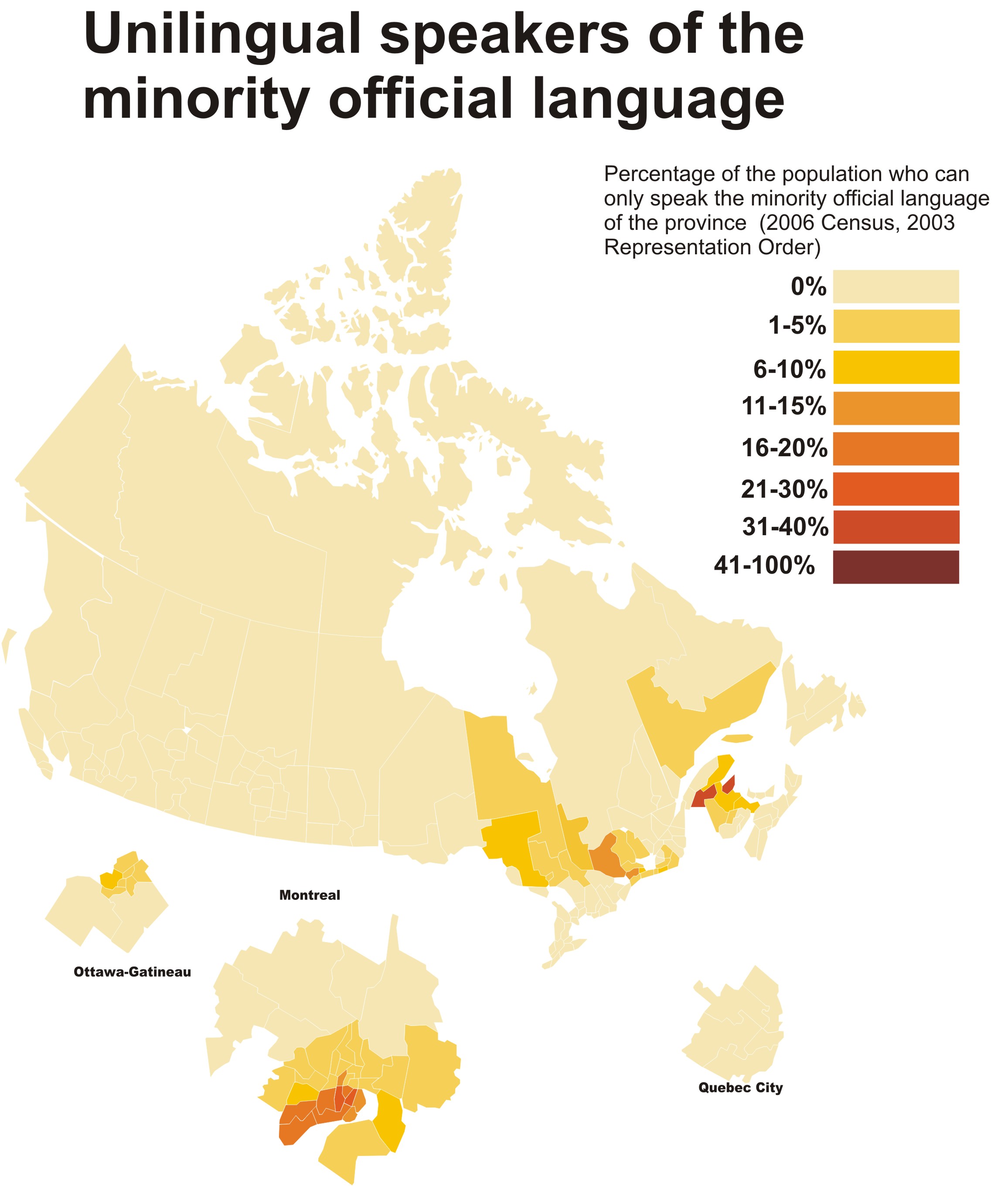
English: Map of Canada showing the percentage of the population which does not speak the majority official language (those who speak only English or English and a non-official language in Quebec, and those who speak only French or French and a non-official language in the rest of Canada, based on the 2006 census and 2003 representation order. |
| Date | (UTC) |
| Source | |
| Author |
|
| This is a retouched picture, which means that it has been digitally altered from its original version. The original can be viewed here: Canada Fed election 2006 Ridings.svg:
|
I, the copyright holder of this work, hereby publish it under the following license:
This file is licensed under the Creative Commons Attribution-Share Alike 2.5 Generic license.
- You are free:
- to share – to copy, distribute and transmit the work
- to remix – to adapt the work
- Under the following conditions:
- attribution – You must give appropriate credit, provide a link to the license, and indicate if changes were made. You may do so in any reasonable manner, but not in any way that suggests the licensor endorses you or your use.
- share alike – If you remix, transform, or build upon the material, you must distribute your contributions under the same or compatible license as the original.
Original upload log
This image is a derivative work of the following images:
- File:Canada_Fed_election_2006_Ridings.svg licensed with Cc-by-sa-2.5
- 2009-08-22T23:59:32Z Lokal Profil 1200x1500 (728227 Bytes) Converted text to paths. Use the previous revision for derivative works and corrections. The font used was Gotham Medium
- 2009-08-22T23:58:50Z Lokal Profil 1200x1500 (593012 Bytes) == {{int:filedesc}} == {{Information |Description={{en|1=This is a riding by riding map of the 2006 Canadian federal election.}} |Source=Created by [[User:Lokal_Profil|Lokal_Profil]]. *SVG source: Modified from: [[:File:Blank
Uploaded with derivativeFX
File history
Click on a date/time to view the file as it appeared at that time.
| Date/Time | Thumbnail | Dimensions | User | Comment | |
|---|---|---|---|---|---|
| current | 17:42, 6 July 2010 | | 2,312 × 2,719 (423 KB) | Spicy Mayan Chocolate | {{Information |Description={{en|1=Map of Canada showing the percentage of the population which does not speak the majority official language (those who speak only English or English and a non-official language in Quebec, and those who speak only French or |
File usage
The following pages on the English Wikipedia use this file (pages on other projects are not listed):
Global file usage
The following other wikis use this file:
- Usage on be-tarask.wikipedia.org
- Usage on be.wikipedia.org