
Size of this preview: 642 × 599 pixels. Other resolutions: 257 × 240 pixels | 514 × 480 pixels | 823 × 768 pixels | 1,097 × 1,024 pixels | 1,479 × 1,381 pixels.
Original file (1,479 × 1,381 pixels, file size: 1.64 MB, MIME type: image/png)
| This is a file from the Wikimedia Commons. Information from its description page there is shown below. Commons is a freely licensed media file repository. You can help. |
Summary
| Description |
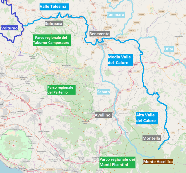
Italiano: Mappa del percorso del fiume Calore Irpino o C. Beneventano (in azzurro), con i suoi tre affluenti principali Ufita, Tammaro e Sabato (in celeste), il monte Accellica da cui sorge (in marrone) e la confluenza nel Volturno (in blu).
English: Course map of the river Calore Irpino, also named C. Beneventano (in azure), with its three main tributaries Ufita, Tammaro and Sabato (in nn-photo blue), its source on Mount Accellica (in brown) and its mouth in the Volturno river (in violet blue). |
| Date | |
| Source | OpenStreetMap |
| Author |
Italiano: Eleborazione di VallVit su lavoro degli Autori di OpenStreetMap.
English: Edit by VallVit on previous work made by OpenStreetMap authors. |
Licensing
| This work contains information from OpenStreetMap, which is made available under the Open Database License (ODbL).
The ODbL does not require any particular license for maps produced from ODbL data. Prior to 1 August 2020, map tiles produced by the OpenStreetMap Foundation were licensed under the CC-BY-SA-2.0 license. Maps produced by other people may be subject to other licences. |
File history
Click on a date/time to view the file as it appeared at that time.
| Date/Time | Thumbnail | Dimensions | User | Comment | |
|---|---|---|---|---|---|
| current | 15:27, 2 August 2018 | | 1,479 × 1,381 (1.64 MB) | VallVit | User created page with UploadWizard |
File usage
The following pages on the English Wikipedia use this file (pages on other projects are not listed):
Global file usage
The following other wikis use this file:
- Usage on it.wikipedia.org