
Size of this PNG preview of this SVG file: 512 × 250 pixels. Other resolutions: 320 × 156 pixels | 640 × 313 pixels | 1,024 × 500 pixels | 1,280 × 625 pixels | 2,560 × 1,250 pixels.
Original file (SVG file, nominally 512 × 250 pixels, file size: 67 KB)
| This is a file from the Wikimedia Commons. Information from its description page there is shown below. Commons is a freely licensed media file repository. You can help. |
Summary
| Description |
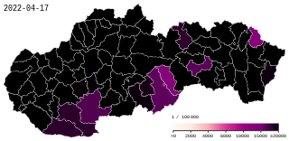
English: COVID19 in Slovakia - Cumulative positive cases by 100.000 inhabitants. Gradient steps: >0 2,000 4,000 6,000 10,000 15,000 ≥ 20,000 Okres titles include numbers for current / updated relative and absolute cases. |
| Data table | Data:COVID-19 Slovakia - Cases per capita.tab |
| Date | |
| Source |
|
| Author | Xplus1 |
| SVG development | This map was created with an unknown SVG tool. |
| Camera location | | View this and other nearby images on: OpenStreetMap |
|---|

|
This file may be updated to reflect new information. If you wish to use a specific version of the file without new updates being mirrored, please upload the required version as a separate file. |
Licensing
I, the copyright holder of this work, hereby publish it under the following license:
This file is licensed under the Creative Commons Attribution-Share Alike 4.0 International license.
- You are free:
- to share – to copy, distribute and transmit the work
- to remix – to adapt the work
- Under the following conditions:
- attribution – You must give appropriate credit, provide a link to the license, and indicate if changes were made. You may do so in any reasonable manner, but not in any way that suggests the licensor endorses you or your use.
- share alike – If you remix, transform, or build upon the material, you must distribute your contributions under the same or compatible license as the original.
File history
Click on a date/time to view the file as it appeared at that time.
| Date/Time | Thumbnail | Dimensions | User | Comment | |
|---|---|---|---|---|---|
| current | 16:12, 17 April 2022 | | 512 × 250 (67 KB) | XplusMapBot | data 2022-04-17, 1.388.659 total, map diff: 48 = 0.00% |
| 16:12, 16 April 2022 |  | 512 × 250 (67 KB) | XplusMapBot | data 2022-04-16, 1.388.611 total, map diff: 291 = 0.02% | |
| 16:12, 15 April 2022 |  | 512 × 250 (67 KB) | XplusMapBot | data 2022-04-15, 1.388.320 total, map diff: 1.634 = 0.12% | |
| 16:12, 14 April 2022 |  | 512 × 250 (67 KB) | XplusMapBot | data 2022-04-14, 1.386.686 total, map diff: 1.607 = 0.12% | |
| 16:12, 13 April 2022 |  | 512 × 250 (67 KB) | XplusMapBot | data 2022-04-13, 1.385.079 total, map diff: 1.668 = 0.12% | |
| 16:12, 12 April 2022 |  | 512 × 250 (67 KB) | XplusMapBot | data 2022-04-12, 1.383.411 total, map diff: 2.908 = 0.21% | |
| 16:12, 11 April 2022 |  | 512 × 250 (67 KB) | XplusMapBot | data 2022-04-11, 1.380.503 total, map diff: 435 = 0.03% | |
| 16:12, 10 April 2022 |  | 512 × 250 (67 KB) | XplusMapBot | data 2022-04-10, 1.380.068 total, map diff: 1.088 = 0.08% | |
| 16:12, 9 April 2022 |  | 512 × 250 (67 KB) | XplusMapBot | data 2022-04-09, 1.378.980 total, map diff: 2.182 = 0.16% | |
| 16:12, 8 April 2022 |  | 512 × 250 (67 KB) | XplusMapBot | data 2022-04-08, 1.376.798 total, map diff: 1.997 = 0.15% |
File usage
No pages on the English Wikipedia use this file (pages on other projects are not listed).
Global file usage
The following other wikis use this file:
- Usage on ca.wikipedia.org
- Usage on cs.wikipedia.org
- Usage on de.wikipedia.org
- Usage on es.wikipedia.org
- Usage on eu.wikipedia.org
- Usage on fa.wikipedia.org
- Usage on hu.wikipedia.org
- Usage on it.wikipedia.org
- Usage on lv.wikipedia.org
- Usage on pt.wikipedia.org
- Usage on ru.wikipedia.org
- Usage on sk.wikipedia.org
- Usage on vi.wikipedia.org
- Usage on www.wikidata.org