
Original file (2,464 × 1,632 pixels, file size: 3.68 MB, MIME type: image/jpeg)
| This is a file from the Wikimedia Commons. Information from its description page there is shown below. Commons is a freely licensed media file repository. You can help. |
Summary
| Description |
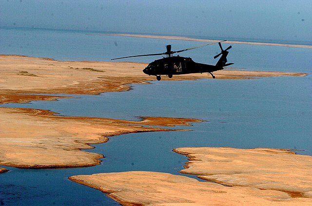
US Army helicopter over Buhayrat al-Habbaniyah, or Lake Habbaniyah, Iraq. An aerial photo tour of Salah ad Din province was taken by provincial leaders to highlight its archaeological sites and economic development in May 2008. The 1st Brigade Combat Team, 101st Airborne Division has partnered with the province on significant gains. In Salah ad Din province, over 800 men have reconciled, economic activity is flourishing, attacks have dropped and thousands of Shiite pilgrims visited the Al Askari shrine in Samarra. 1st Brigade Combat Team, 101st Airborne Division (AA) Public Affairs Photo by Maj. John Paul Arnold Date Taken:05.11.2008 Location:SALAH AD DIN, IQ Related Photos: dvidshub.net/r/j7fmjy |
| Date | |
| Source |
|
| Author | DVIDSHUB |
| Camera location | | View this and other nearby images on: OpenStreetMap |
|---|
Licensing
- You are free:
- to share – to copy, distribute and transmit the work
- to remix – to adapt the work
- Under the following conditions:
- attribution – You must give appropriate credit, provide a link to the license, and indicate if changes were made. You may do so in any reasonable manner, but not in any way that suggests the licensor endorses you or your use.
| This image, originally posted to Flickr, was reviewed on January 13, 2011 by the administrator or reviewer File Upload Bot (Magnus Manske), who confirmed that it was available on Flickr under the stated license on that date. |
File history
Click on a date/time to view the file as it appeared at that time.
| Date/Time | Thumbnail | Dimensions | User | Comment | |
|---|---|---|---|---|---|
| current | 01:22, 13 January 2011 | | 2,464 × 1,632 (3.68 MB) | File Upload Bot (Magnus Manske) | {{Information |Description=An aerial photo tour of Salah ad Din province was taken by provincial leaders to highlight its archaeological sites and economic development in May 2008. The 1st Brigade Combat Team, 101st Airborne Division has partnered with th |
File usage
Global file usage
The following other wikis use this file:
- Usage on ceb.wikipedia.org
- Usage on de.wikipedia.org
- Usage on es.wikipedia.org
- Usage on fr.wikipedia.org
- Usage on it.wikipedia.org
- Usage on nn.wikipedia.org
- Usage on no.wikipedia.org
- Usage on ru.wikipedia.org
- Usage on sv.wikipedia.org
- Usage on www.wikidata.org
- Usage on zh.wikipedia.org