
Size of this PNG preview of this SVG file: 800 × 550 pixels. Other resolutions: 320 × 220 pixels | 640 × 440 pixels | 1,024 × 704 pixels | 1,280 × 880 pixels | 2,560 × 1,761 pixels | 2,800 × 1,926 pixels.
Original file (SVG file, nominally 2,800 × 1,926 pixels, file size: 1.13 MB)
| This is a file from the Wikimedia Commons. Information from its description page there is shown below. Commons is a freely licensed media file repository. You can help. |
Summary
| Camera location | | View this and other nearby images on: OpenStreetMap |
|---|
| Description |
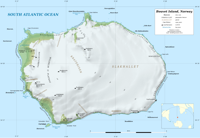
Deutsch: Topografische Karte von Bouvetinsel
English: Topographic map in English of Bouvet Island
Français : Carte topographique en anglais de l’île Bouvet. Scale: 1:80,000 (precision: 20 m for the topography and ground features)
|
||
| Date | |||
| Source |
data:
|
||
| Author | Eric Gaba (Sting - fr:Sting) | ||
| Permission (Reusing this file) |
|
||
| Other versions |
[]
|


Licensing
I, the copyright holder of this work, hereby publish it under the following license:
This file is licensed under the Creative Commons Attribution-Share Alike 4.0 International license.
- You are free:
- to share – to copy, distribute and transmit the work
- to remix – to adapt the work
- Under the following conditions:
- attribution – You must give appropriate credit, provide a link to the license, and indicate if changes were made. You may do so in any reasonable manner, but not in any way that suggests the licensor endorses you or your use.
- share alike – If you remix, transform, or build upon the material, you must distribute your contributions under the same or compatible license as the original.
File history
Click on a date/time to view the file as it appeared at that time.
| Date/Time | Thumbnail | Dimensions | User | Comment | |
|---|---|---|---|---|---|
| current | 15:05, 17 April 2022 | | 2,800 × 1,926 (1.13 MB) | Sting | Display correction on locator map |
| 18:21, 23 February 2020 |  | 2,800 × 1,926 (1.13 MB) | Sting | Display problems for some texts | |
| 18:01, 22 February 2020 |  | 2,800 × 1,926 (887 KB) | Sting | == {{int:filedesc}} == {{Location|54|25|00|S|003|21|00|E|scale:100000}} {{Information |Description= {{de|Topografische Karte von Bouvetinsel}} {{en|Topographic map in English of Bouvet Island}} {{fr|Carte topographique en anglais de l’île Bouvet.}}<br/> Scale: 1:80,000 (precision: 20 m for the topography and ground features)<br/> Equirectangular projection, WGS84 datum<br/> *Central parallel: 54.41995° S<br/> |Source=data:<br/> *[h... |
File usage
The following pages on the English Wikipedia use this file (pages on other projects are not listed):
Global file usage
The following other wikis use this file:
- Usage on de.wikipedia.org
- Bouvetinsel
- Kap Valdivia
- Kap Lollo
- Gjest Baardsenstøtta
- Bennskjera
- Norvegiaodden
- Bollevika
- Catoodden
- Larsøya
- Horn-Riff
- Litle-Kari
- Store-Kari
- Lindsayskjeret
- Kap Meteor
- Norris-Riff
- Norvegiabåen
- Rustadkollen
- Spiessbåane
- Williams-Riff
- Mottesundet
- Djevleporten
- Svarthamaren (Bouvetinsel)
- Nyrøysa
- Ole Høilandstøtta
- Nyknausen
- Randibåen
- Selodden
- Skarven (Insel)
- Randtoppen
- Wilhelm-II.-Plateau
- Keisarryggen
- Skoddenuten
- Mosbytoppane
- Eimstupet
- Mokollen
- Moseryggen
- Usage on es.wikipedia.org
- Usage on fo.wikipedia.org
- Usage on ja.wikipedia.org
View more global usage of this file.