No higher resolution available.
Bay-of-Piran_maritime-boundary-dispute.jpg (709 × 600 pixels, file size: 160 KB, MIME type: image/jpeg)
| This is a file from the Wikimedia Commons. Information from its description page there is shown below. Commons is a freely licensed media file repository. You can help. |
Summary

|
File:Bay-of-Piran maritime-boundary-dispute.svg is a vector version of this file. It should be used in place of this JPG file when not inferior.
File:Bay-of-Piran maritime-boundary-dispute.jpg → File:Bay-of-Piran maritime-boundary-dispute.svg
For more information, see Help:SVG. |
 |
| Description |
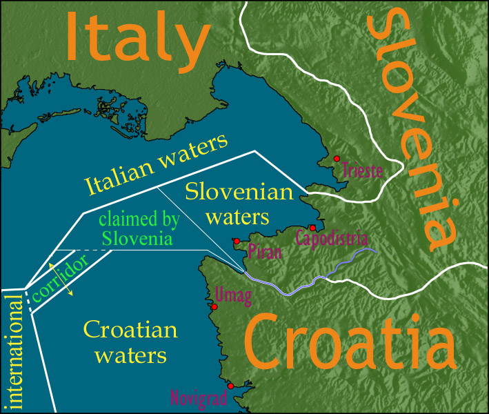
English: Map showing a diplomatic dispute resulting from Slovenia's desire to obtain a direct corridor from its own territorial waters to international waters, to avoid the necessity of Slovenian ships having to sail through the territorial waters of any other country to get to the high seas. Slovenia's only seacoast is in the Bay of Piran / Gulf of Trieste (as shown in this map), and its only commercial seaport is Capodistria / Koper (the eastern of the two red dots in Slovenia on this map), while Italy and Croatia both have long seacoasts outside the area shown in this map.
Slovenia's claim to the area labelled with green text, and the existence of a corridor to international waters, would have been allowed by Croatia under the Drnovšek-Račan agreement, but this was never ratified by either countries' parliaments. This is an English version of image de:Bild:Grenzstreit-Bucht-von-Piran.jpg, created using image Image:BorderDispute_BayOfPiran_blank.png. Raw Adobe Photoshop PSD files (with all text on different type layers) are available on request. |
| Date | |
| Source | File:BorderDispute_BayOfPiran_blank.png |
| Author |
|
| Permission (Reusing this file) |
The underlying source Image:BorderDispute_BayOfPiran_blank.png is declared to be GFDL, while I declare my changes to it to be PD. |
| Other versions | Derivative works of this file: Bay-of-Piran maritime-boundary-dispute.svg |

Licensing

|
Permission is granted to copy, distribute and/or modify this document under the terms of the GNU Free Documentation License, Version 1.2 or any later version published by the Free Software Foundation; with no Invariant Sections, no Front-Cover Texts, and no Back-Cover Texts. A copy of the license is included in the section entitled GNU Free Documentation License. |
| This file is licensed under the Creative Commons Attribution-Share Alike 3.0 Unported license. | ||
| ||
| This licensing tag was added to this file as part of the GFDL licensing update. |
File history
Click on a date/time to view the file as it appeared at that time.
| Date/Time | Thumbnail | Dimensions | User | Comment | |
|---|---|---|---|---|---|
| current | 14:17, 8 January 2007 | | 709 × 600 (160 KB) | AnonMoos | adding city names |
| 18:13, 24 December 2006 |  | 709 × 600 (156 KB) | AnonMoos | deepening colors slightly | |
| 14:00, 14 December 2006 |  | 709 × 600 (156 KB) | AnonMoos | Map showing diplomatic dispute over Slovenia's desire to obtain a direct corridor from its own territorial waters to international waters, to avoid Slovenian ships having to sail through the territorial waters of any other country to get to the high seas. |
File usage
The following pages on the English Wikipedia use this file (pages on other projects are not listed):
Global file usage
The following other wikis use this file:
- Usage on de.wikipedia.org
- Usage on en.wikinews.org
- Usage on es.wikipedia.org
- Usage on fy.wikipedia.org
- Usage on it.wikipedia.org
- Usage on ja.wikipedia.org
- Usage on ko.wikipedia.org
- Usage on pl.wikipedia.org
- Usage on sl.wikipedia.org
- Usage on zh.wikipedia.org