
Size of this preview: 633 × 600 pixels. Other resolutions: 253 × 240 pixels | 507 × 480 pixels | 811 × 768 pixels | 1,081 × 1,024 pixels | 2,336 × 2,213 pixels.
Original file (2,336 × 2,213 pixels, file size: 9.84 MB, MIME type: image/png)
| This is a file from the Wikimedia Commons. Information from its description page there is shown below. Commons is a freely licensed media file repository. You can help. |
| Description |
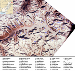
English: Baltoro region from space. Many mountains (e.g. K2, Broad Peak, Gasherbrums, Trango Towers) and glaciers are marked. |
| Date |
(UTC) 2000-02-14 |
| Source | |
| Author |
|
| Other versions | Image:Baltororegion aus dem Weltraum - deutsch.png (deutsche Beschriftung - German Annotations) |
| This is a retouched picture, which means that it has been digitally altered from its original version. Modifications: ISS-image rotated, cropped, marked, pk-map.png included, region marked with a red circle. The original can be viewed here: Karakoram ISS.jpg:
|
| This is a retouched picture, which means that it has been digitally altered from its original version. Modifications: ISS-image rotated, cropped, marked, pk-map.png included, region marked with a red circle. The original can be viewed here: Pk-map.png:
|
This file is licensed under the Creative Commons Attribution-Share Alike 3.0 Unported license.
- You are free:
- to share – to copy, distribute and transmit the work
- to remix – to adapt the work
- Under the following conditions:
- attribution – You must give appropriate credit, provide a link to the license, and indicate if changes were made. You may do so in any reasonable manner, but not in any way that suggests the licensor endorses you or your use.
- share alike – If you remix, transform, or build upon the material, you must distribute your contributions under the same or compatible license as the original.
Original upload log
This image is a derivative work of the following images:
- Image:Pk-map.png licensed with PD-USGov-CIA-WF
- 2005-03-04T20:56:46Z Alfio 330x354 (14233 Bytes) CIA map of Pakistan
Uploaded with derivativeFX
File history
Click on a date/time to view the file as it appeared at that time.
| Date/Time | Thumbnail | Dimensions | User | Comment | |
|---|---|---|---|---|---|
| current | 15:56, 21 November 2008 | | 2,336 × 2,213 (9.84 MB) | Rupert Pupkin | {{Information |Description={{en|1=Baltoro region from space. Many mountains (e.g. K2, Broad Peak, Gasherbrums, Trango Towers) and glaciers are marked. |Source=*Image:Pk-map.png |Date=2008-11-21 15:50 (UTC) |Author=*derivative work: ~~~ *[[:Image:Pk- |
File usage
The following pages on the English Wikipedia use this file (pages on other projects are not listed):
Global file usage
The following other wikis use this file:
- Usage on arz.wikipedia.org
- Usage on az.wikipedia.org
- Usage on bn.wikipedia.org
- Usage on ca.wikipedia.org
- Usage on da.wikipedia.org
- Usage on de.wikipedia.org
- Usage on es.wikipedia.org
- Usage on eu.wikipedia.org
- Usage on fa.wikipedia.org
- Usage on fr.wikipedia.org
- Usage on gl.wikipedia.org
- Usage on hi.wikipedia.org
- Usage on hu.wikipedia.org
- Usage on incubator.wikimedia.org
- Usage on it.wikipedia.org
- Usage on ja.wikipedia.org
- Usage on ko.wikipedia.org
- Usage on lld.wikipedia.org
- Usage on mai.wikipedia.org
- Usage on mk.wikipedia.org
- Usage on ne.wikipedia.org
- Usage on nl.wikipedia.org
- Usage on no.wikipedia.org
- Usage on pa.wikipedia.org
View more global usage of this file.