File:Baltimore Rail Plan.svg

Original file(SVG file, nominally 3,600 × 3,200 pixels, file size: 160 KB)

Summary

Description
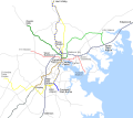
English: A geographic map showing the system proposed in the 2002 Baltimore Rail Plan. The system consists of 6 lines:
  • Green Line (heavy rail): opened 1983 as Metro Subway; eastern extension in planning
  • Blue Line (light rail): opened 1992 as part of MTA Light Rail
  • Yellow Line (light rail): opened in 1992 as part of MTA light rail; southern extension and new northern routing proposed
  • Red Line (light rail): currently in planning
  • Orange Line (multiple unit service): proposed
  • Purple Line (multiple unit service): proposed

The north-south light rail line is heavily modified in this plan from its current state: the yellow and blue colors are switched (currently the yellow-signed route serves Cromwell and the blue-signed route BWI Airport), and they are changed from differently-signed services on the same line to differently-colored lines. The new Yellow Line is rerouted to a street-running section for much of the northern section.

This map does not reflect current plans, which call for a shorter Green Line extension and a non-branched Red Line. However, it serves to illustrate the 2002 plan which will likely influence rail development in Baltimore for decades to come.
Date
Source Own work
Author Pi.1415926535

Licensing

I, the copyright holder of this work, hereby publish it under the following licenses:
w:en:Creative Commons
attribution share alike
This file is licensed under the Creative Commons Attribution-Share Alike 3.0 Unported license.
You are free:
  • to share – to copy, distribute and transmit the work
  • to remix – to adapt the work
Under the following conditions:
  • attribution – You must give appropriate credit, provide a link to the license, and indicate if changes were made. You may do so in any reasonable manner, but not in any way that suggests the licensor endorses you or your use.
  • share alike – If you remix, transform, or build upon the material, you must distribute your contributions under the same or compatible license as the original.
GNU head Permission is granted to copy, distribute and/or modify this document under the terms of the GNU Free Documentation License, Version 1.2 or any later version published by the Free Software Foundation; with no Invariant Sections, no Front-Cover Texts, and no Back-Cover Texts. A copy of the license is included in the section entitled GNU Free Documentation License.
You may select the license of your choice.

Captions

Add a one-line explanation of what this file represents

Items portrayed in this file

depicts

29 May 2012

image/svg+xml

315e2a941894f5353633fe9f940fbb48349fd9b9

163,471 byte

3,200 pixel

3,600 pixel

File history

Click on a date/time to view the file as it appeared at that time.

Date/TimeThumbnailDimensionsUserComment
current22:05, 23 March 2013Thumbnail for version as of 22:05, 23 March 20133,600 × 3,200 (160 KB)Pi.1415926535Location of station names
05:46, 1 June 2012Thumbnail for version as of 05:46, 1 June 20123,600 × 3,200 (159 KB)Pi.1415926535Correct names: BWI Marshall Airport; Owings Mills
02:16, 1 June 2012Thumbnail for version as of 02:16, 1 June 20123,600 × 3,200 (159 KB)Pi.1415926535Never mind - Texas is proposed for future revenue service
02:15, 1 June 2012Thumbnail for version as of 02:15, 1 June 20123,600 × 3,200 (158 KB)Pi.1415926535Remove Texas - not a revenue station
03:14, 30 May 2012Thumbnail for version as of 03:14, 30 May 20123,600 × 3,200 (159 KB)Pi.1415926535{{Information |Description ={{en|1=A geographic map showing the system proposed in the [http://www.baltimorerailplan.com/linked_files/brreportfinal.pdf 2002 Baltimore Rail Plan]. The system consists of 6 lines: *'''Green Line''' (heavy rail): opene...
The following pages on the English Wikipedia use this file (pages on other projects are not listed):

Global file usage

The following other wikis use this file:

Metadata