No higher resolution available.
AzovseaNASA2.jpg (643 × 553 pixels, file size: 143 KB, MIME type: image/jpeg)
| This is a file from the Wikimedia Commons. Information from its description page there is shown below. Commons is a freely licensed media file repository. You can help. |
Summary
| Description |
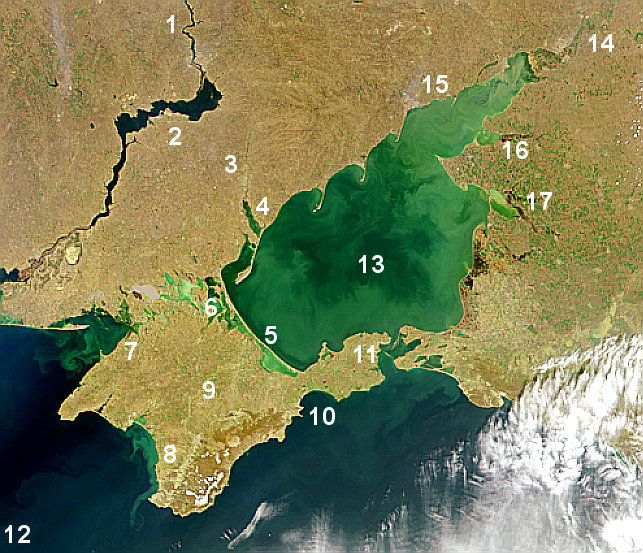
English: Satellite view of Azov Sea area. 1. Dnieper River, 2. Kakhovka Reservoir, 3. Molochna River, 4. Molochny Liman, 5. Arabat Spit, 6. Sivash lagoon system, 7. Karkinit Bay, 8. Kalamitsky Bay, 9. Crimea, 10. Fedosiysky Bay, 11. Strait of Kerch, 12. Black Sea, 13. Sea of Azov, 14. Don River (Russia), 15. Taganrog Bay, 16. Yeysk Liman, 17. Beisug Liman |
| Date | circa 2000? |
| Source | http://veimages.gsfc.nasa.gov/802/S2000104100904.png |
| Author | NASA |
Licensing
| This file is in the public domain in the United States because it was solely created by NASA. NASA copyright policy states that "NASA material is not protected by copyright unless noted". (See Template:PD-USGov, NASA copyright policy page or JPL Image Use Policy.) | ||
 |
Warnings:
|
File history
Click on a date/time to view the file as it appeared at that time.
| Date/Time | Thumbnail | Dimensions | User | Comment | |
|---|---|---|---|---|---|
| current | 02:01, 17 June 2010 | | 643 × 553 (143 KB) | Materialscientist | {{Information |Description={{en|1=Satellite view of Azov Sea area. 1. Dnieper River 2. Kakhovka Reservoir 3. Molochna River 4. Molochny Liman 5. Arabat Spit 6. Sivash lagoon system 7. Karkinit Bay 8. Kalamitsky Bay 9. Crimea 10 |
File usage
The following pages on the English Wikipedia use this file (pages on other projects are not listed):
Global file usage
The following other wikis use this file:
- Usage on am.wikipedia.org
- Usage on ca.wikipedia.org
- Usage on cs.wikipedia.org
- Usage on da.wikipedia.org
- Usage on de.wikipedia.org
- Usage on eo.wikipedia.org
- Usage on es.wikipedia.org
- Usage on fa.wikipedia.org
- Usage on fr.wikipedia.org
- Usage on fy.wikipedia.org
- Usage on hr.wikipedia.org
- Usage on is.wikipedia.org
- Usage on it.wikipedia.org
- Usage on ja.wikipedia.org
- Usage on mk.wikipedia.org
- Usage on nl.wikipedia.org
- Usage on nn.wikipedia.org
- Usage on no.wikipedia.org
- Usage on pl.wikipedia.org
- Usage on pl.wiktionary.org
- Usage on sr.wikipedia.org
- Usage on ta.wikipedia.org
- Usage on vi.wikipedia.org
- Usage on zh.wikipedia.org