Size of this preview: 800 × 486 pixels. Other resolutions: 320 × 194 pixels | 640 × 388 pixels | 1,168 × 709 pixels.
Original file (1,168 × 709 pixels, file size: 401 KB, MIME type: image/jpeg)
| This is a file from the Wikimedia Commons. Information from its description page there is shown below. Commons is a freely licensed media file repository. You can help. |

|
This map image could be re-created using vector graphics as an SVG file. This has several advantages; see Commons:Media for cleanup for more information. If an SVG form of this image is available, please upload it and afterwards replace this template with
{{vector version available|new image name}}.
It is recommended to name the SVG file “Arpitan francoprovencal map.svg”—then the template Vector version available (or Vva) does not need the new image name parameter. |


Summary
| Description |
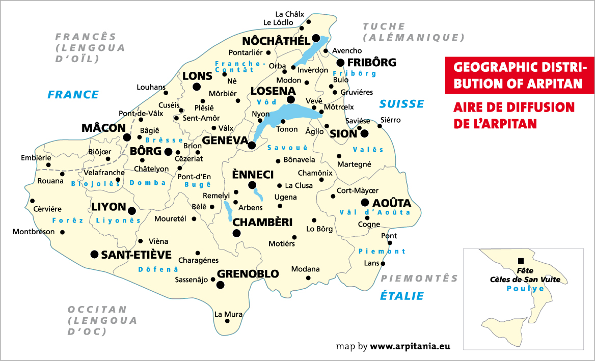
English: Arpitan (Franco-Provençal) language map with placenames in Arpitan language.
Français : Carte de la zone de diffusion de la langue arpitane (ou francoprovençale) avec indications géographiques en arpitan (orthographe codifiée ORB). |
||
| Date | |||
| Source | Own work | ||
| Author | Savoyerli | ||
| Permission (Reusing this file) |
|
||
| Other versions | Revision of Fichier:Francoprovencal-Arpitan-Map.jpg submitted by User:Charvex, 1er décembre 2007. |
Licensing
I, the copyright holder of this work, hereby publish it under the following licenses:

|
Permission is granted to copy, distribute and/or modify this document under the terms of the GNU Free Documentation License, Version 1.2 or any later version published by the Free Software Foundation; with no Invariant Sections, no Front-Cover Texts, and no Back-Cover Texts. A copy of the license is included in the section entitled GNU Free Documentation License. |
This file is licensed under the Creative Commons Attribution-Share Alike 3.0 Unported, 2.5 Generic, 2.0 Generic and 1.0 Generic license.
- You are free:
- to share – to copy, distribute and transmit the work
- to remix – to adapt the work
- Under the following conditions:
- attribution – You must give appropriate credit, provide a link to the license, and indicate if changes were made. You may do so in any reasonable manner, but not in any way that suggests the licensor endorses you or your use.
- share alike – If you remix, transform, or build upon the material, you must distribute your contributions under the same or compatible license as the original.
You may select the license of your choice.
File history
Click on a date/time to view the file as it appeared at that time.
| Date/Time | Thumbnail | Dimensions | User | Comment | |
|---|---|---|---|---|---|
| current | 08:38, 14 May 2015 | | 1,168 × 709 (401 KB) | Savoyerli | Màj, correction, complément langues voisines. |
| 18:14, 1 September 2009 |  | 843 × 520 (106 KB) | Savoyerli | {{Information |Description={{en|1=Arpitan (Franco-Provençal) language map with placenames in Arpitan language.}} {{fr|1=Carte de la zone de diffusion de la langue arpitane (ou francoprovençale) avec indications géographiques en arpitan (orthographe cod |
File usage
The following pages on the English Wikipedia use this file (pages on other projects are not listed):
Global file usage
The following other wikis use this file:
- Usage on bn.wikipedia.org
- Usage on br.wikipedia.org
- Usage on ca.wikipedia.org
- Usage on de.wikipedia.org
- Usage on eo.wikipedia.org
- Usage on es.wikipedia.org
- Usage on eu.wikipedia.org
- Usage on frp.wikipedia.org
- Usage on fr.wikipedia.org
- Usage on fr.wiktionary.org
- Usage on he.wikipedia.org
- Usage on id.wikipedia.org
- Usage on is.wikipedia.org
- Usage on it.wikipedia.org
- Usage on ko.wikipedia.org
- Usage on ku.wikipedia.org
- Usage on lmo.wikipedia.org
- Usage on mk.wikipedia.org
- Usage on nl.wikipedia.org
- Usage on nn.wikipedia.org
- Usage on oc.wikipedia.org
- Usage on pcd.wikipedia.org
- Usage on pl.wikipedia.org
- Usage on pt.wikipedia.org
- Usage on rm.wikipedia.org
- Usage on ro.wikipedia.org
View more global usage of this file.