
Size of this preview: 800 × 529 pixels. Other resolutions: 320 × 212 pixels | 640 × 424 pixels | 896 × 593 pixels.
Original file (896 × 593 pixels, file size: 677 KB, MIME type: image/jpeg)
| This is a file from the Wikimedia Commons. Information from its description page there is shown below. Commons is a freely licensed media file repository. You can help. |
Summary
| Description |
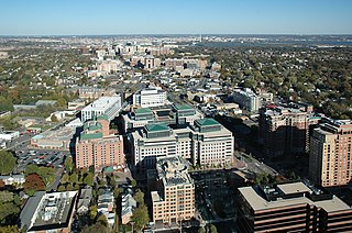
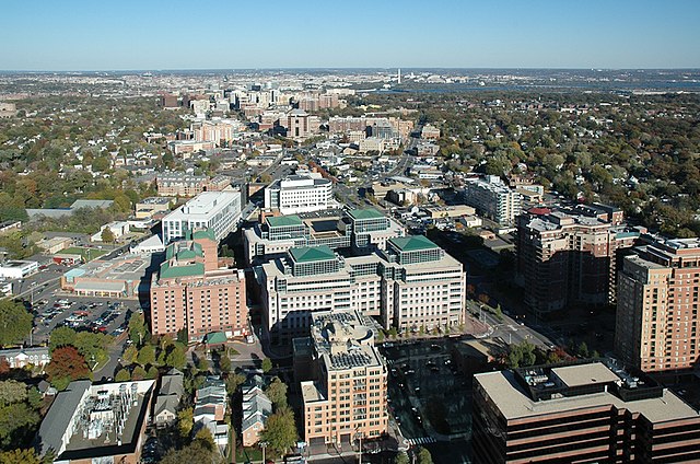
English: View of the central urbanized axis, developed along the Fairfax Drive and Clarendon Boulevard in Arlington County, Virginia, USA. The axis is long approximately 3 miles (4.5 km) and is figuratively perpendicular to the Potomac River which separates the county from the city of Washington. The Washington Monument obelisk is clearly visible in the background. |
| Date | |
| Source | https://www.flickr.com/photos/arlingtonva/5221498943/in/photostream/ |
| Author |
|
| Camera location | | View this and other nearby images on: OpenStreetMap |
|---|
Licensing
| This image, originally posted to Flickr, was reviewed on 5 March 2012 by the administrator or reviewer Sreejithk2000, who confirmed that it was available on Flickr under the stated license on that date. |
This file is licensed under the Creative Commons Attribution-Share Alike 2.0 Generic license.
- You are free:
- to share – to copy, distribute and transmit the work
- to remix – to adapt the work
- Under the following conditions:
- attribution – You must give appropriate credit, provide a link to the license, and indicate if changes were made. You may do so in any reasonable manner, but not in any way that suggests the licensor endorses you or your use.
- share alike – If you remix, transform, or build upon the material, you must distribute your contributions under the same or compatible license as the original.
| Annotations | This image is annotated: View the annotations at Commons |


|
This image has been assessed under the valued image criteria and is considered the most valued image on Commons within the scope: Arlington County urban center, Virginia. You can see its nomination here. |
File history
Click on a date/time to view the file as it appeared at that time.
| Date/Time | Thumbnail | Dimensions | User | Comment | |
|---|---|---|---|---|---|
| current | 15:11, 5 March 2012 | | 896 × 593 (677 KB) | MrPanyGoff | more broghtness |
| 15:09, 5 March 2012 |  | 896 × 593 (654 KB) | MrPanyGoff |
File usage
The following pages on the English Wikipedia use this file (pages on other projects are not listed):
Global file usage
The following other wikis use this file:
- Usage on ar.wikipedia.org
- Usage on cs.wikipedia.org
- Usage on es.wikipedia.org
- Usage on fa.wikipedia.org
- Usage on fi.wikipedia.org
- Usage on hu.wikipedia.org
- Usage on id.wikipedia.org
- Usage on lt.wikipedia.org
- Usage on nl.wikipedia.org
- Usage on pt.wikipedia.org
- Usage on tr.wikipedia.org