.jpg)
.jpg&action=edit&redlink=1)

Size of this preview: 800 × 533 pixels. Other resolutions: 320 × 213 pixels | 640 × 426 pixels | 1,024 × 682 pixels | 1,280 × 853 pixels | 2,560 × 1,705 pixels | 3,600 × 2,398 pixels.
Original file (3,600 × 2,398 pixels, file size: 8.78 MB, MIME type: image/jpeg)
| This is a file from the Wikimedia Commons. Information from its description page there is shown below. Commons is a freely licensed media file repository. You can help. |
.jpg)
Summary
| Description |
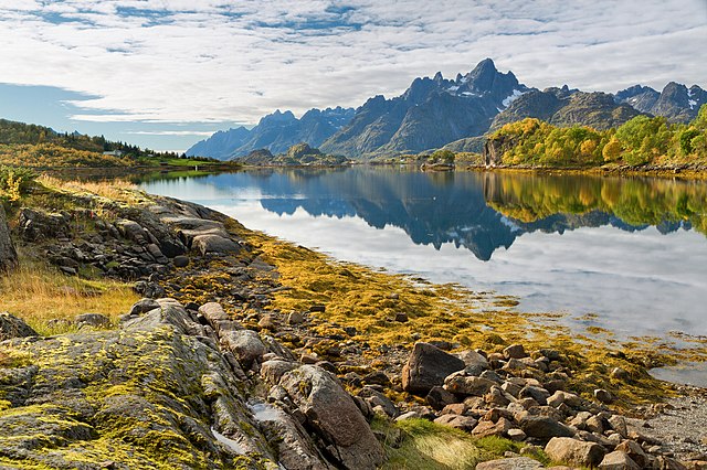
English: An autumn view to Raftsundet and mountains of Austvågøya (including Trolltindan) over Tennfjorden, Hinnøya, Norway in 2015 September.
Español: Vista otoñal de Raftsundet y las montañas de Austvågøya (incluido Trolltindan) sobre Tennfjorden, Hinnøya, Noruega.
Українська: Осінній вид на Рафтсундет і гори Австраґоя і Тролліндан над Тенн-фьордом, Нурланн, Норвегія.
Bosanski: Jesenji pogled na Raftsundet i planine Austvågøya (uključujući Trolltindan) preko Tennfjordena, Hinnøya, Norveška.
Magyar: Az Austvågøy hegyeinek és a Trollryggen-csúcs őszi látképe Raftsundet felé tekintve (Tennfjorden, Hinnøya, Norvégia)
Nederlands: Blik vanaf Hinnøya richting Raftsundet en de bergen op Austvågøy (waaronder Trolltindan) in Noorwegen
Português: Vista de outono no estreito Raftsundet e nas montanhas de Austvågøy (incluindo o pico Trollryggen) sobre Tennfjorden, Hinnøya, Noruega.
Čeština: Podzimní pohled na průliv Raftsundet a ostrov Austvågøya s horou Trolltindan nad fjordem Tennfjorden a ostrovem Hinnøya v severním Norsku.
العربية: مشهد خريفي لرافتسندت وجبال أوستفاغويا في منطقة هانويا في النرويج.
Italiano: Vista autunnale di Raftsundet e le montagne del Austvågøya (inclusa la Trolltindan) sul Tennfjorden, Hinnøya, Norvegia. |
| Date | |
| Source | Own work |
| Author | Ximonic (Simo Räsänen) |
| Camera location | | View this and other nearby images on: OpenStreetMap |
|---|
.jpg¶ms=068.356645_N_0015.072985_E_globe:Earth_type:camera__&language=en)
Assessment
|
.jpg)
This image was selected as picture of the day on Wikimedia Commons for 7 April 2021. It was captioned as follows: English: An autumn view to Raftsundet and mountains of Austvågøya (including Trolltindan) over Tennfjorden, Hinnøya, Norway. Other languages:
Bosanski: Jesenji pogled na Raftsundet i planine Austvågøya (uključujući Trolltindan) preko Tennfjordena, Hinnøya, Norveška. Čeština: Podzimní pohled na průliv Raftsundet a ostrov Austvågøya s horou Trolltindan nad fjordem Tennfjorden a ostrovem Hinnøya v severním Norsku. English: An autumn view to Raftsundet and mountains of Austvågøya (including Trolltindan) over Tennfjorden, Hinnøya, Norway. Español: Vista otoñal de Raftsundet y las montañas de Austvågøya (incluido Trolltindan) sobre Tennfjorden, Hinnøya, Noruega. Italiano: Vista autunnale di Raftsundet e le montagne del Austvågøya (inclusa la Trolltindan) sul Tennfjorden, Hinnøya, Norvegia. Magyar: Az Austvågøy hegyeinek és a Trollryggen-csúcs őszi látképe Raftsundet felé tekintve (Tennfjorden, Hinnøya, Norvégia) Nederlands: Blik vanaf Hinnøya richting Raftsundet en de bergen op Austvågøy (waaronder Trolltindan) in Noorwegen Português: Vista de outono no estreito Raftsundet e nas montanhas de Austvågøy (incluindo o pico Trollryggen) sobre Tennfjorden, Hinnøya, Noruega. Українська: Осінній вид на Рафтсундет і гори Австраґоя і Тролліндан над Тенн-фьордом, Нурланн, Норвегія. العربية : مشهد خريفي لرافتسندت وجبال أوستفاغويا في منطقة هانويا في النرويج. |
Licensing
This file is licensed under the Creative Commons Attribution-Share Alike 3.0 Unported license.
- You are free:
- to share – to copy, distribute and transmit the work
- to remix – to adapt the work
- Under the following conditions:
- attribution – You must give appropriate credit, provide a link to the license, and indicate if changes were made. You may do so in any reasonable manner, but not in any way that suggests the licensor endorses you or your use.
- share alike – If you remix, transform, or build upon the material, you must distribute your contributions under the same or compatible license as the original.
File history
Click on a date/time to view the file as it appeared at that time.
| Date/Time | Thumbnail | Dimensions | User | Comment | |
|---|---|---|---|---|---|
| current | 14:47, 3 November 2015 | | 3,600 × 2,398 (8.78 MB) | Ximonic | Another try, wrong file |
| 14:46, 3 November 2015 |  | 3,600 × 2,400 (4.63 MB) | Ximonic | brightness | |
| 14:29, 3 November 2015 |  | 3,600 × 2,398 (8.67 MB) | Ximonic | VicuñaUploader 1.20 |
File usage
No pages on the English Wikipedia use this file (pages on other projects are not listed).
Global file usage
The following other wikis use this file:
- Usage on alt.wikipedia.org
- Usage on av.wikipedia.org
- Usage on be-tarask.wikipedia.org
- Usage on crh.wikipedia.org
- Usage on cv.wikipedia.org
- Usage on de.wikivoyage.org
- Usage on fr.wikipedia.org
- Usage on hu.wikipedia.org
- Usage on hy.wikipedia.org
- Usage on it.wiktionary.org
- Usage on ka.wikipedia.org
- Usage on ko.wikipedia.org
- Usage on lbe.wikipedia.org
- Usage on lb.wikipedia.org
- Usage on lez.wikipedia.org
- Usage on lmo.wiktionary.org
- Usage on mk.wikipedia.org
- Usage on os.wikipedia.org
- Usage on pt.wikipedia.org
- Usage on ru.wikipedia.org
- Usage on ru.wikinews.org
- Usage on sah.wikipedia.org
- Usage on sc.wikipedia.org
- Usage on sr.wikipedia.org
- Usage on tt.wikipedia.org
- Usage on uk.wikipedia.org
- Usage on vep.wikipedia.org
- Usage on vi.wikipedia.org
- Usage on zh.wikipedia.org
.jpg)