File:Aerial view looking down at Manhattan Tower. Jet Lowe, photographer, 1982. - Brooklyn Bridge, Spanning East River between Park Row, Manhattan and Sands Street, Brooklyn, New York HAER NY,31-NEYO,90-37.tif

Size of this JPG preview of this TIF file: 738 × 599 pixels. Other resolutions: 296 × 240 pixels | 591 × 480 pixels | 946 × 768 pixels | 1,261 × 1,024 pixels | 2,522 × 2,048 pixels | 4,665 × 3,789 pixels.
Original file (4,665 × 3,789 pixels, file size: 16.86 MB, MIME type: image/tiff)
| This is a file from the Wikimedia Commons. Information from its description page there is shown below. Commons is a freely licensed media file repository. You can help. |
Summary
| Aerial view looking down at Manhattan Tower. Jet Lowe, photographer, 1982. - Brooklyn Bridge, Spanning East River between Park Row, Manhattan and Sands Street, Brooklyn, New York, New York County, NY
( |
||||||||||||||||||||||||
|---|---|---|---|---|---|---|---|---|---|---|---|---|---|---|---|---|---|---|---|---|---|---|---|---|
| Photographer |
Related names:
|
|||||||||||||||||||||||
| Title |
Aerial view looking down at Manhattan Tower. Jet Lowe, photographer, 1982. - Brooklyn Bridge, Spanning East River between Park Row, Manhattan and Sands Street, Brooklyn, New York, New York County, NY |
|||||||||||||||||||||||
| Depicted place | New York; New York County; New York | |||||||||||||||||||||||
| Date | 1982 | |||||||||||||||||||||||
| Dimensions | height: 4 in (10.1 cm); width: 5 in (12.7 cm) | |||||||||||||||||||||||
| Current location |
Library of Congress Prints and Photographs Division Washington, D.C. 20540 USA http://hdl.loc.gov/loc.pnp/pp.print |
|||||||||||||||||||||||
| Accession number |
HAER NY,31-NEYO,90-37 |
|||||||||||||||||||||||
| Credit line |
|
|||||||||||||||||||||||
| Notes |
|
|||||||||||||||||||||||
| References |
|
|||||||||||||||||||||||
| Source | https://www.loc.gov/pictures/item/ny1234.photos.120527p | |||||||||||||||||||||||
| Permission (Reusing this file) |
|
|||||||||||||||||||||||
.jpg)

| Object location | | View this and other nearby images on: OpenStreetMap |
|---|
File history
Click on a date/time to view the file as it appeared at that time.
| Date/Time | Thumbnail | Dimensions | User | Comment | |
|---|---|---|---|---|---|
| current | 15:14, 29 July 2014 | 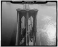 | 4,665 × 3,789 (16.86 MB) | Fæ | GWToolset: Creating mediafile for Fæ. HABS 24 July 2014 (2301:2600) |
File usage
No pages on the English Wikipedia use this file (pages on other projects are not listed).
Global file usage
The following other wikis use this file:
- Usage on zh.wikipedia.org