
Size of this PNG preview of this SVG file: 593 × 398 pixels. Other resolutions: 320 × 215 pixels | 640 × 430 pixels | 1,024 × 687 pixels | 1,280 × 859 pixels | 2,560 × 1,718 pixels.
Original file (SVG file, nominally 593 × 398 pixels, file size: 53 KB)
| This is a file from the Wikimedia Commons. Information from its description page there is shown below. Commons is a freely licensed media file repository. You can help. |
Summary
| Description | |
| Date | |
| Source |
English: Own work, from :
Français : Own work, d'après :
|
| Author | Sémhur |
| SVG development | |
| Attribution (required by the license) | © Sémhur / Wikimedia Commons / |
| Camera location | | View this and other nearby images on: OpenStreetMap |
|---|
Licensing
I, the copyright holder of this work, hereby publish it under the following licenses:
| Copyleft: This work of art is free; you can redistribute it and/or modify it according to terms of the Free Art License. You will find a specimen of this license on the Copyleft Attitude site as well as on other sites. |
This file is licensed under the Creative Commons Attribution-Share Alike 4.0 International, 3.0 Unported, 2.5 Generic, 2.0 Generic and 1.0 Generic license.
- You are free:
- to share – to copy, distribute and transmit the work
- to remix – to adapt the work
- Under the following conditions:
- attribution – You must give appropriate credit, provide a link to the license, and indicate if changes were made. You may do so in any reasonable manner, but not in any way that suggests the licensor endorses you or your use.
- share alike – If you remix, transform, or build upon the material, you must distribute your contributions under the same or compatible license as the original.
You may select the license of your choice.
File history
Click on a date/time to view the file as it appeared at that time.
| Date/Time | Thumbnail | Dimensions | User | Comment | |
|---|---|---|---|---|---|
| current | 14:48, 20 April 2021 | | 593 × 398 (53 KB) | Εὐθυμένης | File uploaded using svgtranslate tool (https://svgtranslate.toolforge.org/). Added translation for el. |
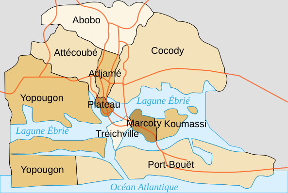
| 13:41, 9 December 2007 |  | 593 × 398 (42 KB) | Sémhur | {{Information |Description= {{en|Map of the communes of Abidjan, Ivory Coast.}} {{fr|Carte des communes d'Abidjan, Côte d'Ivoire.}} |Source=travail personnel, from : * fr:Image:Abidjancouleur.PNG by [[:fr:User:Francky |
File usage
The following pages on the English Wikipedia use this file (pages on other projects are not listed):
Global file usage
The following other wikis use this file:
- Usage on ar.wikipedia.org
- Usage on azb.wikipedia.org
- Usage on bxr.wikipedia.org
- Usage on cs.wikipedia.org
- Usage on de.wikipedia.org
- Abidjan
- Abobo
- Cocody
- Treichville
- Diskussion:Regierungskrise in der Elfenbeinküste 2010/2011
- Adjamé
- Yopougon
- Port-Bouët
- Diskussion:Regierungskrise in der Elfenbeinküste 2010/2011/Archiv/1
- Plateau (Gemeinde)
- Koumassi
- Chronik der Regierungskrise in der Elfenbeinküste im März 2011
- Chronik der Regierungskrise in der Elfenbeinküste im April 2011
- Vridi-Kanal
- Usage on de.wikivoyage.org
- Usage on es.wikipedia.org
- Usage on fa.wikipedia.org
- Usage on fr.wikipedia.org
- Usage on gd.wikipedia.org
- Usage on hu.wikipedia.org
- Usage on id.wikipedia.org
- Usage on it.wikipedia.org
- Usage on ja.wikipedia.org
- Usage on ms.wikipedia.org
- Usage on oc.wikipedia.org
- Usage on pap.wikipedia.org
- Usage on pl.wikipedia.org
View more global usage of this file.