Size of this preview: 781 × 600 pixels. Other resolutions: 313 × 240 pixels | 625 × 480 pixels | 1,000 × 768 pixels | 1,280 × 983 pixels | 1,340 × 1,029 pixels.
Original file (1,340 × 1,029 pixels, file size: 210 KB, MIME type: image/png)
| This is a file from the Wikimedia Commons. Information from its description page there is shown below. Commons is a freely licensed media file repository. You can help. |

|
This proposed entity map image could be re-created using vector graphics as an SVG file. This has several advantages; see Commons:Media for cleanup for more information. If an SVG form of this image is available, please upload it and afterwards replace this template with
{{vector version available|new image name}}.
It is recommended to name the SVG file “8FranklinCounties.svg”—then the template Vector version available (or Vva) does not need the new image name parameter. |
| Description |
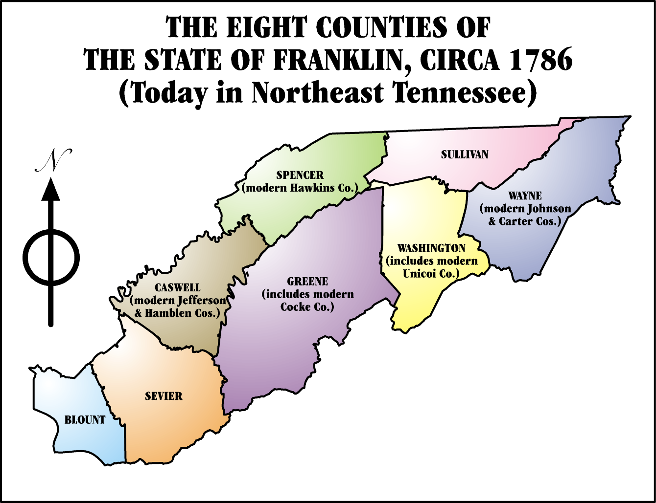
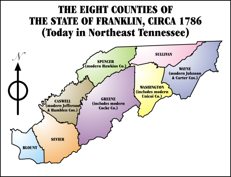
The State of Franklin (1784-1790). State of Franklin was composed of the modern Tennessee counties of:
|
||||||||
| Date | |||||||||
| Source | I, Iamvered, drew this map myself. | ||||||||
| Author | Iamvered | ||||||||
| Permission (Reusing this file) |
I, the copyright holder of this work, hereby publish it under the following license:
|
||||||||
| Other versions |
|

File history
Click on a date/time to view the file as it appeared at that time.
| Date/Time | Thumbnail | Dimensions | User | Comment | |
|---|---|---|---|---|---|
| current | 02:41, 12 April 2008 | | 1,340 × 1,029 (210 KB) | Esemono | {{Information |Description=The State of Franklin (1784-1790) |Source=I, Iamvered, drew this map myself. |Date=00:05, 31 January 2006 |Author=Iamvered |Permission={{GFDL-self-with-discla |
File usage
The following pages on the English Wikipedia use this file (pages on other projects are not listed):
Global file usage
The following other wikis use this file:
- Usage on ca.wikipedia.org
- Usage on da.wikipedia.org
- Usage on de.wikipedia.org
- Usage on fr.wikipedia.org
- Usage on ja.wikipedia.org
- Usage on lt.wikipedia.org
- Usage on ro.wikipedia.org
- Categorie:Guvernatori ai statului Tennessee
- Categorie:Statul Tennessee, SUA
- Tennessee
- Format:Tennessee stat SUA
- Nashville, Tennessee
- Categorie:Formate Tennessee
- Categorie:Liste Tennessee
- Listă de oameni din statul Tennessee
- Categorie:Guvernul statului Tennessee
- Râul Tennessee
- Categorie:Comitatul Washington, Tennessee
- Categorie:Comitatul Wayne, Tennessee
- McLemoresville, Tennessee
- Listă de comitate din statul Tennessee
- McKenzie, Tennessee
- Categorie:Comitatul Carroll, Tennessee
- Huntingdon, Tennessee
- Categorie:Comitatul Anderson, Tennessee
- Categorie:Comitatul Bedford, Tennessee
- Categorie:Zone metropolitane din Tennessee
- Categorie:Zone micropolitane din Tennessee
- Categorie:Comitatul Benton, Tennessee
- Categorie:Comitatul Warren, Tennessee
- Categorie:Comitatul Fayette, Tennessee
- Categorie:Comitatul Union, Tennessee
- Categorie:Comitatul Lincoln, Tennessee
- Categorie:Comitatul Wilson, Tennessee
- Categorie:Localități din Tennessee
- Categorie:Membri ai Camerei Reprezentanților SUA din statul Tennessee
- Categorie:Orașe din Tennessee
- Categorie:Comitatul White, Tennessee
- Categorie:Comitatul Williamson, Tennessee
- Categorie:Comitatul Weakley, Tennessee
- Categorie:Comitatul Henry, Tennessee
- Categorie:Comitatul Bledsoe, Tennessee
- Pikeville, Tennessee
- Categorie:Comitatul Moore, Tennessee
- Categorie:Comitatul Blount, Tennessee
- Categorie:Comitatul Bradley, Tennessee
- Categorie:Comitatul Van Buren, Tennessee
- Categorie:Comitatul Shelby, Tennessee
- Categorie:Comitatul Scott, Tennessee
View more global usage of this file.