
Size of this PNG preview of this SVG file: 606 × 599 pixels. Other resolutions: 243 × 240 pixels | 485 × 480 pixels | 777 × 768 pixels | 1,035 × 1,024 pixels | 2,071 × 2,048 pixels | 2,000 × 1,978 pixels.
Original file (SVG file, nominally 2,000 × 1,978 pixels, file size: 138 KB)
| This is a file from the Wikimedia Commons. Information from its description page there is shown below. Commons is a freely licensed media file repository. You can help. |
Summary
| Description |
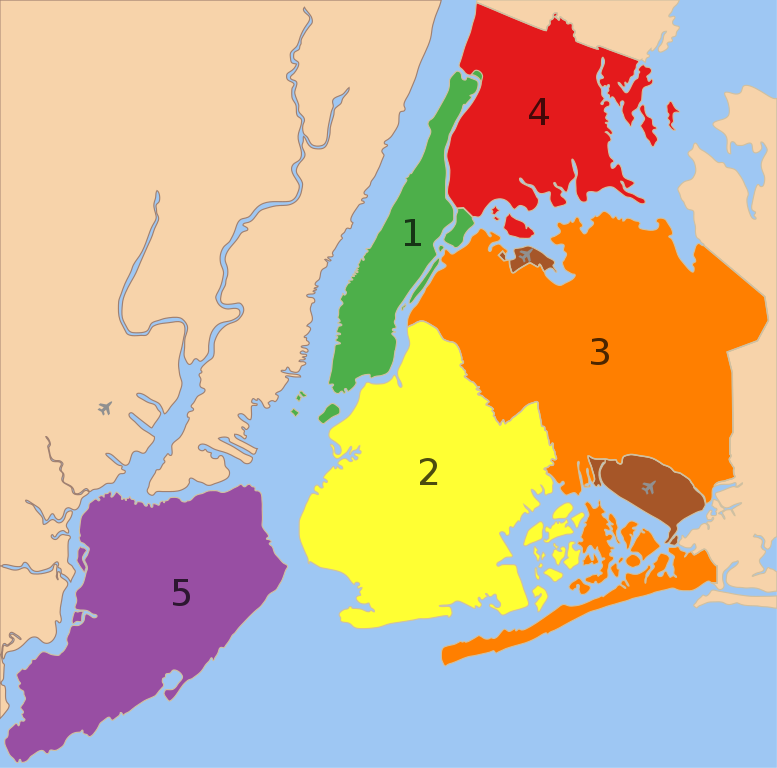
A map showing the five boroughs of New York City, as well as airports. 1. Manhattan
2. Brooklyn
3. Queens
4. Bronx
5. Staten Island
Airports: North East: LGA; South East: JFK; West: EWR |
| Date | |
| Source |
 |
| Author |
|
| Other versions |
 |
Licensing
| This work has been released into the public domain by its author, Nafsadh. This applies worldwide. In some countries this may not be legally possible; if so: |
File history
Click on a date/time to view the file as it appeared at that time.
| Date/Time | Thumbnail | Dimensions | User | Comment | |
|---|---|---|---|---|---|
| current | 22:57, 9 February 2023 | | 2,000 × 1,978 (138 KB) | Nafsadh | Reverted to version as of 18:55, 26 October 2014 (UTC) Intention to not add English label to the svg itself was to keep it mostly language independent and not having to be subject to svg text rendering issues. |
| 08:18, 18 January 2020 |  | 2,000 × 1,978 (150 KB) | Mccbala | Added captions to all 5 boroughs and 2 airports. | |
| 18:55, 26 October 2014 |  | 2,000 × 1,978 (138 KB) | Nafsadh | Cleanup SVG | |
| 10:07, 26 October 2014 |  | 2,000 × 1,978 (138 KB) | Nafsadh | {{Information |Description ={{en|1=5 boroughs}} |Source =File:5_Boroughs_Labels_New_York_City_Map_Julius_Schorzman.png |Author =Julius Schorzman |Date = |Permission = |other_versions = }} |
File usage
The following pages on the English Wikipedia use this file (pages on other projects are not listed):
- Administrative divisions of New York (state)
- Boroughs of New York City
- Demographics of New York City
- List of African American newspapers in New York
- Municipality
- Neighborhoods in New York City
- New York City
- User:Andrewa/New York (overview)
- User:Chronus/sandbox
- User:DoctorShmullus/sandbox2
- User:Nafsadh
- User:Nafsadh/Gallery
- User:Saurabh Mittra/Gather lists/18958 – Saurabh's Articles Collection
Global file usage
The following other wikis use this file:
- Usage on arz.wikipedia.org
- Usage on az.wikipedia.org
- Usage on bn.wikipedia.org
- Usage on br.wikipedia.org
- Usage on bs.wikipedia.org
- Usage on cs.wikipedia.org
- Usage on de.wikipedia.org
- Usage on eml.wikipedia.org
- Usage on en.wikiquote.org
- Usage on fa.wikipedia.org
- Usage on fr.wikipedia.org
- Usage on glk.wikipedia.org
- Usage on hy.wikipedia.org
- Usage on it.wikipedia.org
- Usage on ku.wikipedia.org
- Usage on la.wikipedia.org
- Usage on lfn.wikipedia.org
- Usage on lld.wikipedia.org
- Usage on no.wikipedia.org
- Usage on nso.wikipedia.org
- Usage on oc.wikipedia.org
- Usage on pt.wikipedia.org
- Usage on ru.wikipedia.org
- Usage on sd.wikipedia.org
- Usage on simple.wikipedia.org
- Usage on si.wikipedia.org
View more global usage of this file.