
Size of this preview: 800 × 566 pixels. Other resolutions: 320 × 226 pixels | 640 × 453 pixels | 1,024 × 724 pixels | 1,280 × 905 pixels | 2,718 × 1,922 pixels.
Original file (2,718 × 1,922 pixels, file size: 139 KB, MIME type: image/png)
| This is a file from the Wikimedia Commons. Information from its description page there is shown below. Commons is a freely licensed media file repository. You can help. |
Summary
Completed trail
Proposed trail
| Description |
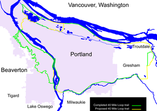
English: Map of the 40 Mile Loop greenway around Portland, Oregon, a 140 mile path connecting city parks. The green portions are complete; the yellow portions are proposed. Created based on Portland City Limits and Urban Service Boundary and 40 Mile Loop Land Trust map. |
| Date | |
| Source | Own work |
| Author | EncMstr |
Licensing
I, the copyright holder of this work, hereby publish it under the following licenses:
This file is licensed under the Creative Commons Attribution-Share Alike 3.0 Unported license.
- You are free:
- to share – to copy, distribute and transmit the work
- to remix – to adapt the work
- Under the following conditions:
- attribution – You must give appropriate credit, provide a link to the license, and indicate if changes were made. You may do so in any reasonable manner, but not in any way that suggests the licensor endorses you or your use.
- share alike – If you remix, transform, or build upon the material, you must distribute your contributions under the same or compatible license as the original.

|
Permission is granted to copy, distribute and/or modify this document under the terms of the GNU Free Documentation License, Version 1.2 or any later version published by the Free Software Foundation; with no Invariant Sections, no Front-Cover Texts, and no Back-Cover Texts. A copy of the license is included in the section entitled GNU Free Documentation License. |
You may select the license of your choice.
File history
Click on a date/time to view the file as it appeared at that time.
| Date/Time | Thumbnail | Dimensions | User | Comment | |
|---|---|---|---|---|---|
| current | 07:26, 6 June 2008 | | 2,718 × 1,922 (139 KB) | EncMstr | {{Information |Description={{en|1=Map of the en:40 Mile Loop greenway around Portland, Oregon, a 140 mile path connecting city parks. The green portions are complete; the yellow portions are proposed. Created based on [http://www.portlandonline |
File usage
The following pages on the English Wikipedia use this file (pages on other projects are not listed):
Global file usage
The following other wikis use this file:
- Usage on zh.wikipedia.org