
Size of this preview: 507 × 599 pixels. Other resolutions: 203 × 240 pixels | 592 × 700 pixels.
Original file (592 × 700 pixels, file size: 895 KB, MIME type: image/png)
| This is a file from the Wikimedia Commons. Information from its description page there is shown below. Commons is a freely licensed media file repository. You can help. |
Summary
| Description |
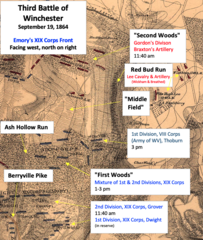
English: This is a map of the front for Brigadier General William H. Emory's XIX Corps in the Third Battle of Winchester of the American Civil War. It occurred on September 19, 1864. |
| Date | |
| Source | This is a portion of an 1873 map titled "Battle field of Winchester, Va. (Opequon) [September 19, 1864]" prepared by an order of Lt. Gen. P.H. Sheridan under the authority of the Secretary of War. The entire map can be found in the Library of Congress map, and shows the whole battlefield. TwoScarsUp has added some labels based on "The Last Battle of Winchester" by Scott C. Patchan and "From Winchester to Cedar Creek" by Jeffry D. Wert. |
| Author | Bvt. Lt. Col. G. L. Gillespie, Major of Engineers, U.S.A. under the authority of the Secretary of War for the map, and labels added by TwoScarsUp |
Licensing
This work is in the public domain in the United States because it is a work prepared by an officer or employee of the United States Government as part of that person’s official duties under the terms of Title 17, Chapter 1, Section 105 of the US Code.
Note: This only applies to original works of the Federal Government and not to the work of any individual U.S. state, territory, commonwealth, county, municipality, or any other subdivision. This template also does not apply to postage stamp designs published by the United States Postal Service since 1978. (See § 313.6(C)(1) of Compendium of U.S. Copyright Office Practices). It also does not apply to certain US coins; see The US Mint Terms of Use.
|
 | |
| This file has been identified as being free of known restrictions under copyright law, including all related and neighboring rights. | ||
File history
Click on a date/time to view the file as it appeared at that time.
| Date/Time | Thumbnail | Dimensions | User | Comment | |
|---|---|---|---|---|---|
| current | 17:07, 28 January 2021 | | 592 × 700 (895 KB) | TwoScarsUp | Uploaded a work by Bvt. Lt. Col. G. L. Gillespie, Major of Engineers, U.S.A. under the authority of the Secretary of War for the map, and labels added by TwoScarsUp from This is a portion of an 1873 map titled "Battle field of Winchester, Va. (Opequon) [September 19, 1864]" prepared by an order of Lt. Gen. P.H. Sheridan under the authority of the Secretary of War. The entire map can be found in the Library of Congress [https://www.loc.gov/item/99446372/ map], and shows the whole battlefield.... |
File usage
The following pages on the English Wikipedia use this file (pages on other projects are not listed):