
Original file (8,313 × 6,326 pixels, file size: 11.27 MB, MIME type: image/jpeg)
| This is a file from the Wikimedia Commons. Information from its description page there is shown below. Commons is a freely licensed media file repository. You can help. |
| Title |
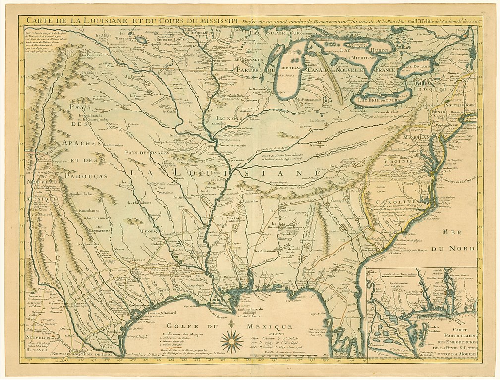
Français : Carte de la Louisiane et du Cours du Mississipi. |
|||||||||||||||||||||||
| Description |
The first detailed map of the Gulf region and the Mississippi, and the first printed map to show Texas. Delisle’s 1718 map of Louisiana is one of the great milestones in the cartographic history of North America in general and in Texas cartography in particular. The most important notation to Texas history, however, was that appearing along the Trinity: ‘Mission de los Teijas, etablie in 1716.’ Referring to the earliest of the Spanish missions in East Texas, this phrase marked the first appearance of a form of the name Texas on a printed map and thus Delisle has received proper credit for establishing Texas as a geographic place name. |
|||||||||||||||||||||||
| Date | ||||||||||||||||||||||||
| Source | Dorothy Sloan Rare Books | |||||||||||||||||||||||
| Creator |
|
|||||||||||||||||||||||
| Permission (Reusing this file) |
|
|||||||||||||||||||||||
| Geotemporal data | ||||||||||||||||||||||||
| Date depicted | ||||||||||||||||||||||||
| Map location | French colonization of the Americas | |||||||||||||||||||||||
| Bounding box |
|
|||||||||||||||||||||||
| Georeferencing | ||||||||||||||||||||||||
| Archival data | ||||||||||||||||||||||||
| Dimensions | height: 48.8 cm (19.2 in); width: 65.2 cm (25.6 in) | |||||||||||||||||||||||
| Medium | Copper-engraved map on two sheets of laid paper | |||||||||||||||||||||||
| Other versions | File:Delisle - Carte de la Louisiane et du Cours du Mississipi.png | |||||||||||||||||||||||

File history
Click on a date/time to view the file as it appeared at that time.
| Date/Time | Thumbnail | Dimensions | User | Comment | |
|---|---|---|---|---|---|
| current | 16:21, 25 June 2017 | | 8,313 × 6,326 (11.27 MB) | Scewing | {{Map |title ={{fr|Carte de la Louisiane et du Cours du Mississipi.}} |description =The first detailed map of the Gulf region and the Mississippi, and the first printed map to show Texas. Delisle’s 1718 map of Louisiana is one of th... |