No higher resolution available.
Übersichtskarte_Loveparade_Duisburg_2010.jpg (400 × 400 pixels, file size: 105 KB, MIME type: image/jpeg)
| This is a file from the Wikimedia Commons. Information from its description page there is shown below. Commons is a freely licensed media file repository. You can help. |

|
This road map image could be re-created using vector graphics as an SVG file. This has several advantages; see Commons:Media for cleanup for more information. If an SVG form of this image is available, please upload it and afterwards replace this template with
{{vector version available|new image name}}.
It is recommended to name the SVG file “Übersichtskarte Loveparade Duisburg 2010.svg”—then the template Vector version available (or Vva) does not need the new image name parameter. |


| Description |
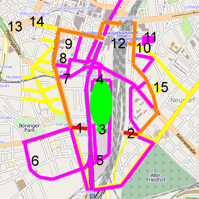
English: Overview on loveparade 2010 in Duisburg |
|||||
| Date | ||||||
| Source | Own work, based on OpenStreetMap data published under CC-BY-SA 2.0 | |||||
| Author | user:axpde | |||||
| Permission (Reusing this file) |
|

| Farbe / Ziffer | Erklärung | Explanation | Ort |
|---|---|---|---|
| Rot | Sicherheitsschleusen | security ports | |
| Orange | Geplante Fußwege | planned Footpaths | |
| Gelb | Tatsächliche genutzte Wege | actually used paths | |
| Magenta | Rettungswege | emergency paths | |
| Grün | Festivalgelände | festival area | |
| 1 | Westliche Sicherheitsschleuse | western security port | Karl-Lehr-Straße / Düsseldorfer Straße |
| 2 | Östliche Sicherheitsschleuse | eastern security port | Karl-Lehr-Straße / Grabenstraße |
| 3 | Haupteingang (zwei 20 m breite Tunnel, eine 50 m breite Rampe) | main entry (two tunnel of 20 m width, a ramp of 50 m width) | Karl-Lehr-Straße |
| 4 | VIP-Eingang / nördlicher Rettungsweg | VIP entry / northern escape way | Am Güterbahnhof |
| 5 | Südlicher Rettungsweg / Sanitätsdienst | southern escape way / medical service | Grunewald |
| 6 | Bethesda-Johanniter-Klinikum | Bethesda Hospitaller clinical center | |
| 7 | VIP-Eingang / Sanitätsdient | VIP entry / medical service | Mercatorstraße |
| 8 | Sanitätsdienstzentrale | central medical service | Steinbart-Gymnasium |
| 9 | Behelfshubschrauberlandeplatz | emergency heliport | Kantpark |
| 10 | Sanitätsdienst | medical service | Kammerstraße, Gertrud-Bäumer-Schule |
| 11 | Behelfshubschrauberlandeplatz | emergency heliport | Ludgeriplatz |
| 12 | Duisburg Hauptbahnhof | Duisburg central station | |
| 13 | Zentraler Omnibusbahnhof / U-Bahnhof | central bus station / underground station | Steinsche Gasse |
| 14 | „Nebenschauplatz“ | „Sideshow“ | Friedrich-Wilhelm-Platz |
| 15 | „Nebenschauplatz“ | „Sideshow“ | Neudorfer Markt |
File history
Click on a date/time to view the file as it appeared at that time.
| Date/Time | Thumbnail | Dimensions | User | Comment | |
|---|---|---|---|---|---|
| current | 17:01, 27 July 2010 | | 400 × 400 (105 KB) | Axpde | some additions |
File usage
The following pages on the English Wikipedia use this file (pages on other projects are not listed):
Global file usage
The following other wikis use this file:
- Usage on ar.wikipedia.org
- Usage on bg.wikipedia.org
- Usage on ca.wikipedia.org
- Usage on de.wikipedia.org
- Usage on fi.wikipedia.org
- Usage on id.wikipedia.org
- Usage on it.wikipedia.org
- Usage on nds.wikipedia.org
- Usage on nl.wikipedia.org
- Usage on ru.wikipedia.org
- Usage on vec.wikipedia.org
- Usage on www.wikidata.org